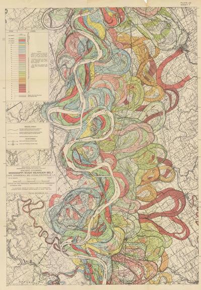
Rivers meander over their course as they continuously erode and deposit sediment. Harold Fisk, a geologist and cartographer working for the US Army Corps of Engineers, mapped the meanders of the mighty Mississippi in 1944 and the results are mesmerizing. They also beautifully illustrate geology’s Law of Superposition: newer and younger sediments are deposited on top of older sediments. We see thousand of years of course changes. You can unravel the layers by eye by noting which layer cuts others
@vickyveritas
For the map geeks:
Some biography on
Harold Norman Fisk
https://www.sciencedirect.com/science/article/abs/pii/S0013795297819552
A nice summary, Radical Cartography from 2008 with georeferenced overview
http://www.radicalcartography.net/index.html?fisk
(USACE link is broken)
Oversized Plates Rectified:
TIFFs from USACE in 700 MB zipped folder
https://tinyurl.com/2p8u4vzu
Download related full publication in high resolution here in a 600 MB PDF:
https://tinyurl.com/54fach28
200 MB Version:
https://tinyurl.com/csncukus
More
https://collections.lib.uwm.edu/digital/collection/agdm/id/7642
#fisk #map