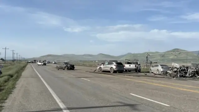
NWS Grand Junction Region:
There's a Freeze Warning for parts of the NWas Grand Junction region tonight (April 3rd) from midnight until 10 am tomorrow. Sub-freezing temperatures as low as 18°.

#COwx #Colorado #UTwx #Utah

@weathermatrix Promoting to #UTwx

#NWS #flood #nwsflashflood #FlashFloodWarning Flash Flood Warning for Emery, UT #UTwx
FFWSLC

The National Weather Service in Salt Lake City has issued a

* Flash Flood Warning for...
South Central Emery County in central Utah...Specifically Little
Wildhorse slot canyon...

* Until 600 PM MDT.

* At 253 PM MDT, local law enforcement reported that heavy rainfall
has produced flash flooding in Little Wildhorse slot canyon. Other
slot canyons in the vicinity are also likely experiencing flash
flooding at this time. Flash flooding is already occurring.

HAZARD...Life threatening flash flooding. Thunderstorms
producing flash flooding.

SOURCE...Law enforcement reported.

IMPACT...Life threatening flash flooding of slot canyons and
normally dry washes.

* Some locations that will experience flash flooding include...
Little Wildhorse, Belle, Ding and Dang slot canyons.

Don't forget to join us for our Colorado Severe Weather/Outlook Net today at 1 pm MT on any SkyhubLink repeater.

You can connect to the Weather Outlook Net via hotspot at AllStar 46079, YSF 92722, BM/DMR 310847, Wires-X 09799. EchoLink is 985839. To merely listen to the outlook on any device, go to https://hose.brandmeister.network/?subscribe=310847.

#COwx #Colorado #WYwx #Wyoming #NEwx #Nebraska #KSwx #Kansas #UTwx #Utah

Hoseline

BrandMeister Hoseline

The seasonal anomalousness, as well sheer spatial extent, of upcoming record-shattering Western U.S. heatwave is genuinely startling. This will be associated with, by far, the strongest ridge ever observed during (at least) any Nov-Mar month. #CAwx #AZwx #NMwx #NVwx #UTwx #COwx

#EAS #WEA for Emery County : High winds may move loose debris, damage property and cause power outages. Travel could be difficult, especially for high profile vehicles and vehicles with trailers. Use extra caution. People are urged to secure loose objects that could be blown around or damaged by the wind. Source: Emery County Sheriffs Office UT #UTwx

** DO NOT RELY ON THIS FEED FOR LIFE SAFETY, SEEK OUT OFFICIAL SOURCES ***

Oooh, good luck on Utah having any more of a ski season. How many days of above freezing temps can the snowpack tolerate?

#skiing #Utah #heatwave #heatdome #UTwx

There is a Winter Weather Advisory, Winter Storm Warning, & Avalanche Warning for much of the Colorado mountains & some of the Utah mountains.

Winter Storm Warning:
Until 11 pm this evening (Feb 20th). Heavy snow. Snow accumulations between 6 and 12 inches with locally higher amounts possible on south and southwest facing slopes. Winds gusting as high as 50 mph. For the eastern San Juan Mountains above 10000 feet. Travel could be difficult. Widespread blowing snow could significantly reduce visibility.

Winter Weather Advisory:
Until 11 pm this evening. Snow expected. Total snow accumulations between 3 to 12 inches. Winds gusting as high as 40 mph. Plan on slippery road conditions. The hazardous conditions could impact the Friday morning and evening commutes.

Avalanche Warning:
-WHEN...6 AM MST FRIDAY THROUGH 6 AM MST SATURDAY.
-AVALANCHE DANGER...THE AVALANCHE DANGER IS HIGH.
-REASON/IMPACTS...HEAVY SNOWFALL ACCOMPANIED BY STRONG WINDS HAS
OVERLOADED PRE-EXISTING WEAK LAYERS IN THE SNOWPACK, CREATING DANGEROUS AVALANCHE CONDITIONS. NATURAL AND HUMAN-TRIGGERED AVALANCHES ARE LIKELY.

#COwx #Colorado #UTwx #Utah