#orienteering
#orienteeringMapping
#orienteeringSwitzerland
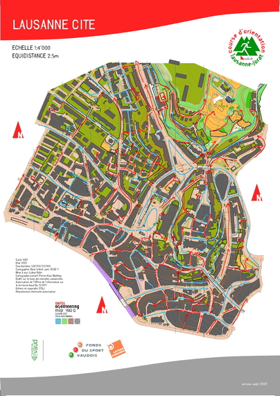
#Lausanne
Next Sunday, the Swiss Champs in Sprint Orienteering are held in Lausanne.

Usually I don't prepare for orienteering, but I somehow stumbled into this one. 😛
The old town of Lausanne with its complex relief, stairs and tunnels invites to a very complex challenge. To mitigate that, I took ten minutes to wrap my head around the topography of the venue.

Looks like fun ahead...

#OrienteeringMapping #orienteering #OCAD
The recent Training for Orienteering Mapping beginners triggered some reflection process, how my own setup looked like if I would actually work with the OCAD app (and solely used OCAD Desktop to build the Field Set). Check out the descrption.
#OrienteeringMapping #Orienteering #SwissOrienteering
Ok. Round four for the annual Swiss Orienteering Mappers Beginner training in #Sursee.
My room got upgraded this year, such as I got this direct view on the training area (Haselwarten Wald).
Rare occasion for mapping from bed.😎🤣
#orienteeringMapping #SwissOrienteering
I am preparing a training for new orienteering mappers to be held next weekend. Reluctant to the AI I am I could not help to generate this picture to depict the relationship between new mappers and the ISOM (International Specification for Orienteering Maps). I will introduce the later as the product of a slightly disappointed father who was hoping he could prevent his kids from making the same mistakes he did in his own mappers youth. :-P

#orienteering #orienteeringMapping #SwissOrienteering

Last autumn, we invited our top mappers to spend a single day mapping a small forest near Sursee (LU), Switzerland. The forest is a typical Mittelland example—nothing spectacular, but full of the usual challenges around generalisation (point features) and vegetation classification.

Now at the Annual Swiss Orienteering Convention in Olten, Mark Gloor presented the results of this experiment.

Check out his slides:
https://www.swiss-orienteering.ch/files/kommission_karten/2026/KT26-03_Aufnahme_Mittellandwald.pdf

#Orienteering #orienteeringMapping
#OLGZürich
#Zürich
Gestern lief ich meinen ersten Indoor-OL anlässlich dem 2. Zürcher Indoor OL im Gebäude de ZHDK, Toni Areal.
Das war soooo geil.🤩 Such a thrill (43 Min. full speed few mistakes)

Angehängt die beiden Laufkarten (try it). Geile Bahnen über 8! Etagen und Karten nach dem aktuellen Draft der ISInOM (neue internationale Indoor Norm) durch Peter Grau und Janine Dünner von der OLG ZH.

🥰

#orienteeringMapping #Orienteering
We celebrate the release of Open Orienteering Mapper v0.9.6. After four years and eight months since the v0.9.5 it is finally here.😍
https://github.com/OpenOrienteering/mapper/releases/tag/v0.9.6
Release v0.9.6 · OpenOrienteering/mapper

All changes since previous release build Enhancements Updated translations. New box zoom tool (GH-2360). Improved contrast of some icons (GH-2357). Map information tool (GH-2125). Symbol set repor...

GitHub
#orienteeringMapping #Zürich #OLZürichByNight
OK. Took me a while but I am making progress (yeah!). Below you can see the base map for mapping Zürich as an Orienteering Sprint map. Really can't wait to start mapping.
#TrailrunningSweden
#GotskaSandön
#orienteeringMapping
Today I ran the second part of the green track on Gotska Sandön, Sweden, while checking the autogenerated map to make corrections also for #OpenStreetMap later on. The trail is.... *badumtss* epic.😁
https://hiking.waymarkedtrails.org/#route?id=14330885&map=12.0/58.3814/19.2269
#OrienteeringMapping #GotskaSandön
To keep me from finetuning the autogenerated map any further, I send it to the printer, Media Perret (our 🇨🇭 o-maps Specialist) to print it as it is on Teslin. 5 sheets of A3. Scale 1:11K to fit. 2.5 m contours and 7.5° declination. What I plan is using the maps this summer, then finetune it a bit and then round the project up with a print on two sheets of #Tyvek 50x70cm