#TNwx #graphicast #MEG
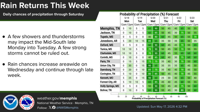
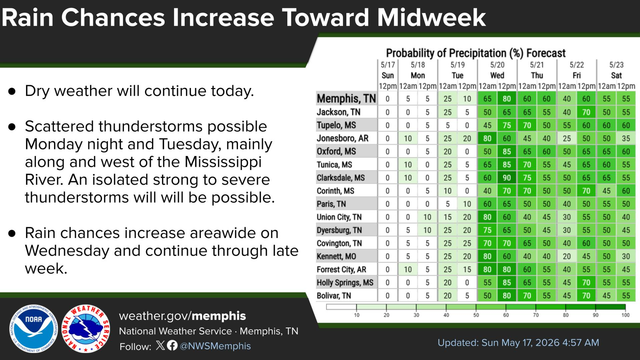
A few showers and thunderstorms cannot be ruled out late Monday into Tuesday, but chances remain around 30%. Greater rain chances return by midweek and last into the upcoming weekend.
#TNwx #graphicast #MEG
Highs are forecast to reach the upper 80s to lower 90s through Tuesday.
Temperatures will decrease on Wednesday as a cold front moves through the Mid-South.
#TNwx #graphicast #MEG
The Storm Prediction Center has issued a Slight Risk (2/5) for severe thunderstorms on Tuesday for northeast Arkansas, the Missouri bootheel and far West Tennessee. A Marginal Risk (1/5) exists for areas to the east. Should a storm reach severe limits, large hail and damaging winds would be primary threats. This is a Medium-Low confidence forecast and the primary period of concern is Tuesday afternoon and evening.
#TNwx #graphicast #MEG
Scattered thunderstorms possible Monday night and Tuesday, mainly along and west of the Mississippi River. An isolated strong to severe thunderstorms will be possible. Rain chances increase areawide on Wednesday and continue through late week.
#TNwx #graphicast #MEG
Highs are forecast to reach the upper 80s to around 90 through Tuesday.
A cold frontal passage will bring moderate temperatures along with showers and scattered thunderstorms over the latter half of the week.
#TNwx #graphicast #MEG
Dry weather will continue today. Scattered thunderstorms possible Monday night and Tuesday, mainly along and west of the Mississippi River. An isolated strong to severe thunderstorms will will be possible. Rain chances increase areawide on Wednesday and continue through late week.
#TNwx #graphicast #MEG
Daily rain chances return next week.
#TNwx #graphicast #MEG
High temps will average 5-10 degrees above normal through Tuesday.
#TNwx #graphicast #MEG
A few showers or sprinkles could occur today, mainly north of I-40. Otherwise dry weather will continue through the weekend.
The weather pattern will shift to more wet and unsettled by Tuesday through late next week.

#TNwx #graphicast #MEG
High temps will average 5-10 degrees above normal through Tuesday.

Rain chances increase by the middle of next week. Temperatures will moderate but humidity will remain.