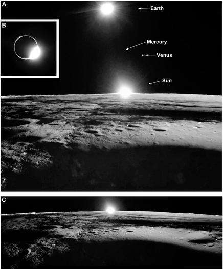
Finally, views looking west very close to sunset. The sun is on the horizon, Earth above it in the top view, with some neighbours peeking into the shot. The light seems to be shining from the wrong direction in the foreground - it is sunlight reflected off Mons Latreille enough to weakly illuminate the surface. An inset (B) shows Earth in eclipse with a nice diamond ring effect. Solar eclipse on the Moon, lunar eclipse on Earth.
#moon #CLPS #firefly #BGM1
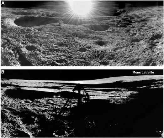
These two views look east, the first just after sunrise, the second near sunset. The volcanic cone Mons Latreille is shown in the lower one and would be visible in the top one except we are looking at its shadowed side and sun glare gets in the way a bit. As far as I know we did not get to see the rest of the hill.
#moon #CLPS #firefly #BGM1
#moon #CLPS #firefly #BGM1
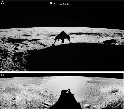
I will finish Firefly's mission with some surface views. These images were taken looking west. The top image was taken just after landing at sunrise with the rising sun casting a long shadow to the west. The lower image was taken later with a higher sun. The wide angle lens makes the very flat horizon look curved. Sunlight reflected off the nearby crater wall made the lander hotter than expected so they took a siesta around local noon.
#moon #CLPS #firefly #BGM1
#moon #CLPS #firefly #BGM1
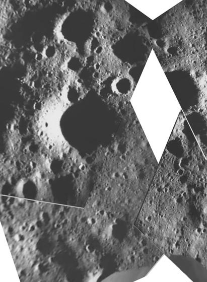
SCALPSS is an experiment from NASA Langley. There were 6 cameras on BGM1 (and 4 on IM-1, 4 more on the Blue Moon Mk1 pathfinder lander coming up soon). They look for surface effects of the rocket plume, which will matter when we have successive landings at places where infrastructure is being assembled - such as Artemis Base Camp. Later images show lots of raised dust, but earlier ones should give me what I need for mapping.
#moon #CLPS #firefly #BGM1
#moon #CLPS #firefly #BGM1
I really want to have two more maps for Firefly's BGM1 mission: an improved version of what I am showing here and a further enlargement showing the space under the lander, locating the drill, Planetvac and other experiment locations, the surface changes created by the landing etc. They have to wait for future publications or presentations. This is a quick version of a map made from SCALPSS (Stereo Cameras for Lunar Plume Surface Studies) images as released so far.
#moon #CLPS #firefly #BGM1
#moon #CLPS #firefly #BGM1
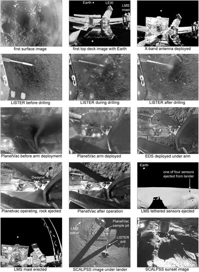
Planetvac ejected a rock - and yes, it was named Dwayne. Not sure why... The SCALPSS image under the lander shows the LISTER drill hole, and beside it a pit with coarser material in the middle... I have labelled it as caused by the Planetvac sampling but it could be from the landing thrusters. Any ideas? I'm waiting for papers on the SCALPSS and Planetvac experiments which I hope will fill in a lot of details.
#moon #CLPS #firefly #BGM1
#moon #CLPS #firefly #BGM1
Firefly landed successfully and operated flawlessly (as far as I can tell), as I am sure you all know. Here is the Firefly web page for the mission:
https://fireflyspace.com/missions/blue-ghost-mission-1/
and here is their image and video site:
https://www.flickr.com/photos/fireflyspace/albums/72177720313239766/
It's nice to look back at the landing video and others here. We have had some failed and partially successful landings in recent years - let's hope for more successes in future.
Here is a quick 'storyboard' summary image.
#moon #CLPS #firefly #BGM1
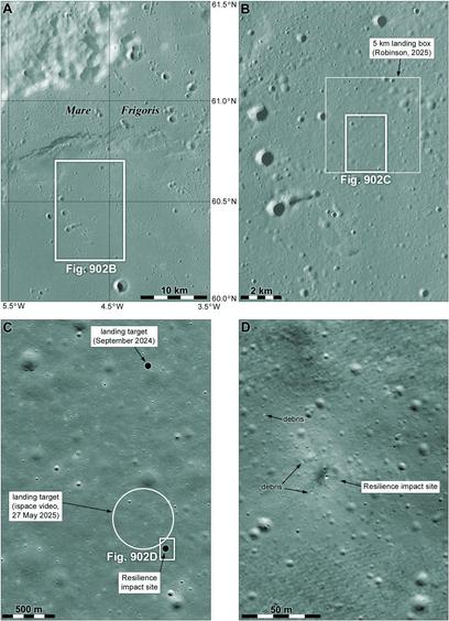
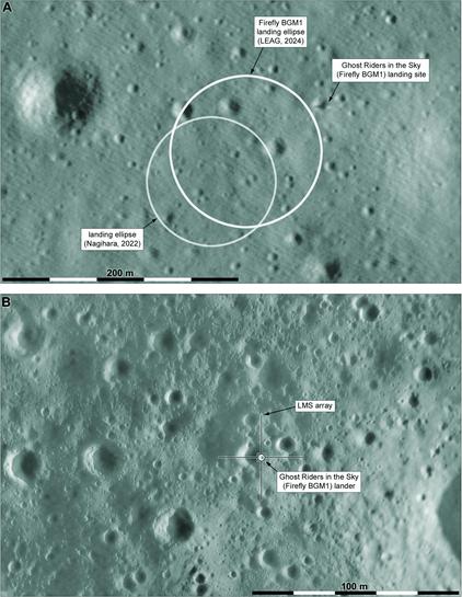
Two more maps take us down to the BGM1 lander. The top image is from LRO, the bottom one is made of spacecraft descent images, using the LRO image as a base to get the geometry right. In the top image the lander and its shadow are visible. In the lower map the lander is drawn in with its LMS (Lunar Magnetotelluric Sounder) array around it. Four projectiles were fired by springs out to about 20 m from the lander, trailing wires which form antennae for the experiment.
#moon #CLPS #firefly #BGM1
#moon #CLPS #firefly #BGM1
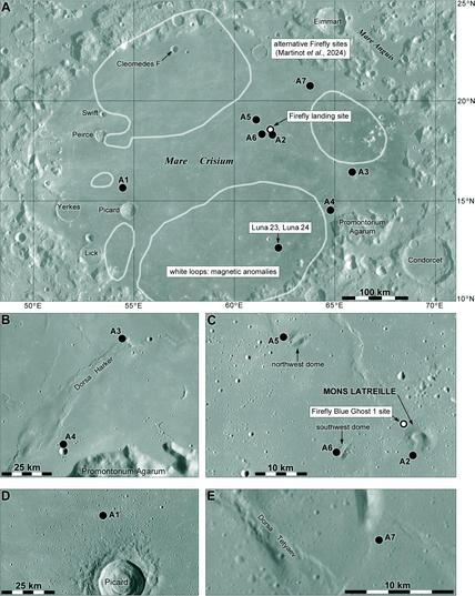
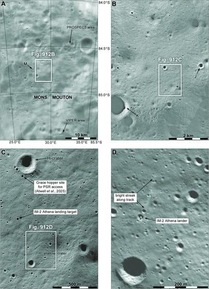
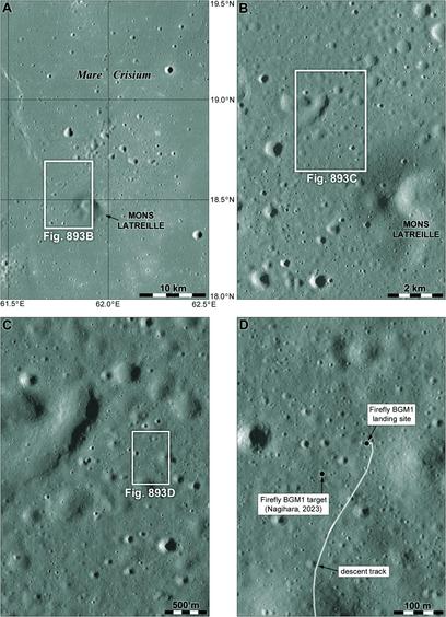
Here is one of my trademark zoom-in sets of images to help locate the Firefly BGM1 landing site. It's quite close to and northwest of a small breached volcanic cone called Mons Latreille. The cone is visible from the landing site but we didn't get a full panorama from the lander (or haven't seen one yet) so we only have a partial view of it. The lower right image shows the descent track meandering up from the south.
#moon #CLPS #firefly #BGM1
#moon #CLPS #firefly #BGM1
What we saw yesterday might be called the official site selection process for Firefly's first lander. But there's more to the story. Often people outside the mission offer suggestions as well, and here we see work by Mélissa Martinot and colleagues looking at alternatives. The work was presented at the European Lunar Symposium in Dumfries, Scotland, in June 2024. The top map here shows the region with 7 suggested sites, with more detail below.
#moon #CLPS #firefly #BGM1
#moon #CLPS #firefly #BGM1