#BIS #NDwx 912
WWUS63 KBIS 080430
WCNBIS

WATCH COUNTY NOTIFICATION FOR WATCH 285
NATIONAL WEATHER SERVICE BISMARCK ND
1130 PM CDT SUN JUN 7 2026

NDC001-013-025-041-055-057-061-065-075-089-101-080530-
/O.CAN.KBIS.SV.A.0285.000000T0000Z-260608T0600Z/

THE NATIONAL WEATHER SERVICE HAS CANCELLED SEVERE THUNDERSTORM
WATCH 285 FOR THE FOLLOWING AREAS

IN NORTH DAKOTA THIS CANCELS 11 COUNTIES

IN NORTH CENTRAL NORTH DAKOTA

RENVILLE WARD

IN N https://mesonet.agron.iastate.edu/vtec/f/2026-O-CON-KBIS-SV-A-0285_2026-06-08T04:31Z

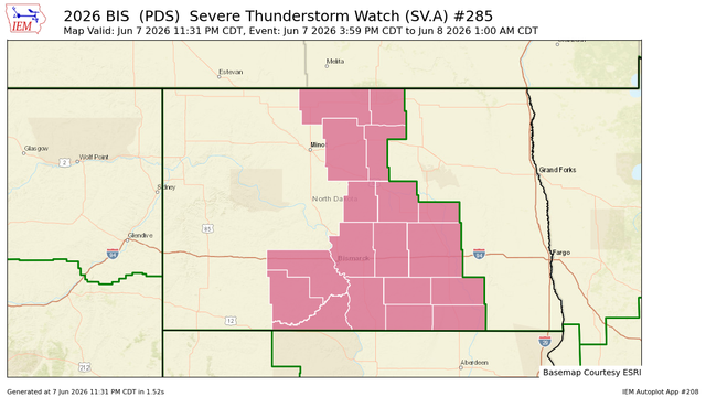
KBIS Severe Thunderstorm (Particularly Dangerous Situation) Watch #285

Grant, Slope, Williams, Rolette, Sheridan, Sioux, Dunn, Billings, Bowman, Divide, Golden Valley, McKenzie, Stark, Ward, Adams, Burke, Hettinger, McLean, Mercer, Mountrail, Oliver, Renville, Dickey, Emmons, Foster, Kidder, LaMoure, Logan, McIntosh, Stutsman, Wells, Bottineau, Burleigh, McHenry, Morton, Pierce

Iowa Environmental Mesonet

#BIS #NDwx 904
WWUS53 KBIS 080428
SVSBIS

Severe Weather Statement
National Weather Service Bismarck ND
1128 PM CDT Sun Jun 7 2026

NDC009-069-079-103-080500-
/O.CON.KBIS.SV.W.0051.000000T0000Z-260608T0500Z/
Bottineau ND-Pierce ND-Rolette ND-Wells ND-
1128 PM CDT Sun Jun 7 2026

...SEVERE THUNDERSTORM WARNING REMAINS IN EFFECT UNTIL MIDNIGHT CDT
FOR EASTERN BOTTINEAU, PIERCE, ROLETTE AND WELLS COUNTIES...

At 1128 PM CDT, severe thunderstorms were located along a line https://mesonet.agron.iastate.edu/vtec/f/2026-O-CON-KBIS-SV-W-0051_2026-06-08T04:28Z

KBIS Severe Thunderstorm Warning #51

McLean, Bottineau, Pierce, Rolette, Wells, McHenry, Sheridan

Iowa Environmental Mesonet

#BIS #NDwx 923
NWUS53 KBIS 080428
LSRBIS

Preliminary Local Storm Report
National Weather Service Bismarck ND
1128 PM CDT Sun Jun 7 2026

..TIME... ...EVENT... ...CITY LOCATION... ...LAT.LON...
..DATE... ....MAG.... ..COUNTY LOCATION..ST.. ...SOURCE....
..REMARKS..

0950 PM Tstm Wnd Gst 10 NE Coleharbor 47.66N 101.08W
06/07/2026 M70 MPH McLean ND Public

Measured wind gust at pr https://mesonet.agron.iastate.edu/lsr/?by=wfo&wfo=BIS&sts=202606080250&ets=202606080250

IEM LSR App

#BIS #NDwx 240
NWUS53 KBIS 080425
LSRBIS

Preliminary Local Storm Report
National Weather Service Bismarck ND
1125 PM CDT Sun Jun 7 2026

..TIME... ...EVENT... ...CITY LOCATION... ...LAT.LON...
..DATE... ....MAG.... ..COUNTY LOCATION..ST.. ...SOURCE....
..REMARKS..

1053 PM Tstm Wnd Gst 4 E Kramer 48.70N 100.63W
06/07/2026 M58 MPH Bottineau ND Public

Measured wind gust at pr https://mesonet.agron.iastate.edu/lsr/?by=wfo&wfo=BIS&sts=202606080353&ets=202606080353

IEM LSR App

#BIS #NDwx 537
WWUS53 KBIS 080426
SVSBIS

Severe Weather Statement
National Weather Service Bismarck ND
1126 PM CDT Sun Jun 7 2026

NDC049-083-080436-
/O.CAN.KBIS.SV.W.0051.000000T0000Z-260608T0500Z/
McHenry ND-Sheridan ND-
1126 PM CDT Sun Jun 7 2026

...SEVERE THUNDERSTORM WARNING IS CANCELLED FOR MCHENRY AND SHERIDAN
COUNTIES...

The storms which prompted the warning have moved out of the area.
Therefore, the warning has been cancelled.

A Severe Thunderstorm Watch r https://mesonet.agron.iastate.edu/vtec/f/2026-O-CON-KBIS-SV-W-0051_2026-06-08T04:26Z

KBIS Severe Thunderstorm Warning #51

McLean, Bottineau, Pierce, Rolette, Wells, McHenry, Sheridan

Iowa Environmental Mesonet
IEM :: ND_ASOS Current Conditions

Iowa Environmental Mesonet of Iowa State University

#BIS #NDwx 089
ACUS11 KWNS 080409
SWOMCD
SPC MCD 080408
NDZ000-SDZ000-080545-

Mesoscale Discussion 1022
NWS Storm Prediction Center Norman OK
1108 PM CDT Sun Jun 07 2026

Areas affected...portions of central North Dakota and northern South
Dakota

Concerning...Severe Thunderstorm Watch 285...

Valid 080408Z - 080545Z

The severe weather threat for Severe Thunderstorm Watch 285
continues.

SUMMARY...A few severe gusts remain possible tonight mainly over
north-central https://www.spc.noaa.gov/products/md/2026/md1022.html

#BIS #NDwx 880
NWUS53 KBIS 080402
LSRBIS

Preliminary Local Storm Report
National Weather Service Bismarck ND
1102 PM CDT Sun Jun 7 2026

..TIME... ...EVENT... ...CITY LOCATION... ...LAT.LON...
..DATE... ....MAG.... ..COUNTY LOCATION..ST.. ...SOURCE....
..REMARKS..

0831 PM Tstm Wnd Gst 9 NNW New Leipzig 46.50N 101.99W
06/07/2026 M63 MPH Grant ND Mesonet

10 meter measured wind g https://mesonet.agron.iastate.edu/lsr/?by=wfo&wfo=BIS&sts=202606080131&ets=202606080131

IEM LSR App

#BIS #NDwx 200
WWUS53 KBIS 080403
SVSBIS

Severe Weather Statement
National Weather Service Bismarck ND
1103 PM CDT Sun Jun 7 2026

NDC101-080413-
/O.CAN.KBIS.SV.W.0050.000000T0000Z-260608T0415Z/
Ward ND-
1103 PM CDT Sun Jun 7 2026

...SEVERE THUNDERSTORM WARNING IS CANCELLED FOR SOUTHEASTERN WARD
COUNTY...

The storm which prompted the warning has moved out of the area.
Therefore, the warning has been cancelled.

A Severe Thunderstorm Watch remains in effect until 100 https://mesonet.agron.iastate.edu/vtec/f/2026-O-CON-KBIS-SV-W-0050_2026-06-08T04:03Z

KBIS Severe Thunderstorm Warning #50

McLean, McHenry, Ward

Iowa Environmental Mesonet

#BIS #NDwx 542
NWUS53 KBIS 080400
LSRBIS

Preliminary Local Storm Report
National Weather Service Bismarck ND
1100 PM CDT Sun Jun 7 2026

..TIME... ...EVENT... ...CITY LOCATION... ...LAT.LON...
..DATE... ....MAG.... ..COUNTY LOCATION..ST.. ...SOURCE....
..REMARKS..

1032 PM Tstm Wnd Gst 9 NNW Wing 47.27N 100.33W
06/07/2026 M67 MPH Burleigh ND Mesonet

10 meter measured wind g https://mesonet.agron.iastate.edu/lsr/?by=wfo&wfo=BIS&sts=202606080332&ets=202606080332

IEM LSR App