Alert 2/16-April: King County will detour vehicle access onto Snoqualmie Valley Trail near Rattlesnake Lake, close the trail to biking and walking

Map of the closure from King County Parks.

As part of ongoing work to make road and other infrastructure repairs following this winter’s intense flooding and rainfall, the Snoqualmie Valley Trail will be closed to walking and biking “as soon as February 16” as crews work to repair the nearby SE Edgewick Road, according to an alert from King County.

This is a very unusual closure because the trail is closed not to repair it but because it is the only viable alternative vehicle detour around the closed roadway for a handful of properties west of the worksite that would be otherwise cut-off from the road network while roadway repairs are underway. “This portion of the trail will be temporarily closed to pedestrian and bicycle users to facilitate safer conditions for vehicle traffic,” according to the project webpage.

The temporary vehicle access route.

It is understandable that these properties need basic roadway access during the 6–8 week closure, and there truly does not seem to be any other option. These are extenuating circumstances. But there is also no viable detour for trail users in this area, and trail users are also members of the public worth serving. This closure creates a similar problem as a bridge replacement project in early autumn 2024. The only real alternative option for folks biking between North Bend and Rattlesnake Lake is to bike on Cedar Falls Road SE, which can be busy (especially on a nice day) and has limited to non-existent shoulders. Discretion is advised.

Given the options, I’d much rather bike on the trail with a limited number of cars using it for temporary property access than ride on Cedar Falls Road. The temporary road access route will not be a through-route, so it shouldn’t have significant traffic flow. People bike mixed with cars on skinny streets all the time, and bikes are legal vehicles that are generally allowed on roadways except for a handful of limited access freeways. The detour instructions on the project website tell people driving on the trail to “keep speed under 10 mph.” If there were some other nearby sidewalk they could use to route trail users, then maybe I could see banning biking and walking on the trail. But King County has no safe detour to offer and does not plan to sign one.

King County Parks has gotten into a bad habit of treating trail trips as optional, but that isn’t always true. Sure, those who are just looking for a nice ride and don’t really care where they go should consider a different route. But there are jobs and homes out there, and people rely on King County trails for transportation. One third of U.S. residents cannot drive, and there is limited transit service in the area (no transit service on weekends). There will also certainly be folks who do not read Seattle Bike Blog and will be surprised by this closure in the middle of a rather remote area. They deserve to be offered a viable option. King County Parks needs to revise its policies so that “there will be no detour” is not longer treated as a catch-all phrase to absolve them of their responsibility to people who use and rely on these trails.

More details from King County Parks:

As soon as February 16, a segment of the Snoqualmie Valley Trail will be closed to people biking and walking to allow for temporary vehicle access while SE Edgewick Road undergoes repairs. The anticipated duration of this closure is approximately 6–8 weeks.

There will be no detour available during this closure. 

When King County Parks closes a trail, safety is our top priority. We carefully evaluate whether a detour is feasible for each closure. Because regional trails are accessible, multi-use facilities, any detour must safely accommodate pedestrians and cyclists of all ages and abilities and meet ADA requirements.

In this location, it is not possible to provide a detour that meets these safety and accessibility standards. We recognize that trail closures are disruptive. King County Parks remains committed to providing advance notice whenever possible, carefully planning the scope and timing of work to minimize impacts, and completing projects as quickly and efficiently as conditions allow. 

Thank you for your patience and understanding as we complete this important work. 

#SEAbikes #Seattle

Alert 11/3-14: Sammamish River Trail ‘intermittent’ closures near NE 175th St + 2 days of full closures, dates TBD

The red marks the approximate work area. The green marks a possible unofficial detour route. Map by Seattle Bike Blog.

King County Parks is fixing a section of pavement on the Sammamish River Trail between NE 178th and NE 175th Streets in Woodinville, so expect “intermittent” closures between November 3 and 14. There will also be two full-day closures at some point during this work period, though those dates have not yet been announced.

Once again, the county is not creating a detour, saying, “No detour is guaranteed during these closures. Please plan for alternate routes.” This is a pattern with King County Parks for trail work, and one more example of why the county needs to create a proper trail detour policy that treats the trail as a transportation corridor rather than just a park for recreation. This is a very busy trail, one of the gems of the region’s trail network. The County must secure a reliable and safe detour option for people.

Bob Svercl and I have both been looking at the options, and there should be an OK detour option via NE 178th St, 130th Ave NE/Little Bear Creek Pkwy, 131st Ave NE, and Wilmot Gateway Park, but this route requires a fence gate at NE 178th St to be open. I believe it usually is open, but technically a few feet of land between the trail and the street might be private property (it is sometimes difficult to know how accurate the Parcel Viewer website is at such a detailed scale and where street right of way begins and ends). I believe the gate is often unlocked, and the Strava heatmap (account needed to zoom in) suggests that trail users pass through the gate fairly often. But if that gate is closed, then I don’t know what people are supposed to do. The two freeways and the river pen the trail into a corridor with no other access points for at least a 1.3 miles to the west, so it will be very important that the gate stays open at all times that the trail is closed.

We need King County to ensure people can access NE 178th and that folks know they need to go all the way to Wilmot Gateway Park or the the south sidewalk on 175th to reconnect to the trail. The connection will not be obvious to users on the ground, which is why signing a detour is important. Not everyone reads Seattle Bike Blog, unfortunately.

Details from King County Parks:

Starting Nov 3-Nov 14, A portion of the Sammamish River Trail between NE 175th St and NE 178th St will experience intermittent closures over a two-week period to remove and repair asphalt on the trail. 

Trail users should expect up to two full 24-hour closures during this work period. Additional shorter closures may occur for striping activities. Single-lane closures may also be required for sign installation. 

No detour is guaranteed during these closures. Please plan for alternate routes. 

Thank you for your patience as we complete these necessary improvements.

Questions? Contact [email protected] or (206) 477-4527. 

#SEAbikes #Seattle

Alert 10/22-11/18: Snoqualmie Valley Trail bridge closed for emergency repairs south of Duvall, no detour provided

Map from King County Parks.

Inspectors “found significant rot” and closed a small bridge on the Snoqualmie Valley Trail south of Duvall about halfway between NE 138th and 124th Streets. King County Parks immediately closed the structure — lovingly named Bridge 2178-15 — for safety reasons October 22, noting that “no detour is available.”

Just a few days after the closure, King County Parks has now announced the repair plan. Crew will begin work October 28, and repairs are expected to take about three weeks to complete. That would put reopening around November 18 if all goes according to schedule. There will be no detour during this time, the department said.

You can find updates for this and other King County Parks projects on their Backyard FunFinder map.

Detour options

In what is a frustrating pattern with King County Parks, the department will not be signing a detour let alone creating any sort of temporary space to help trail users get around the closure safely. This happens too often, and it is not acceptable to leave trail users completely on their own to navigate dangerous traffic conditions. King County needs to treat our regional trails as transportation routes, and that means developing a trail detour policy. The county would never close a road without at least signing a detour, so why should trails be treated any differently?

Options for getting around this trail are pretty much limited to using the shoulders on Carnation-Duvall Road NE. Maps show a private road that crosses the trail just north of the closure, but it has a fence at the main road so is likely not a good option. Instead, users will need to access the trail at NE 138th and 124th Streets. Unlike too many roads in the region with two hyphenated place names, this one at least has consistent shoulders on both sides. The trickiest part is likely the roundabout at NE 124th Street, a horrible double-lane design with no bike lanes or sidewalks. Roundabouts can be a tool for safer streets, but not if they’re designed with only cars in mind like this one. Note that users of the main road can continue “straight” in either lane, which may not be what you expect. Proceed with extreme caution.

From Google Maps.

This is a great example of why King County Parks needs a better detour policy. With just a little work, like clearing out overgrowth and maybe adding some quick pavement to barely widen the sidewalk space on the northwest corner and the first hundred feet or so to the north, they could create a usable walking and biking connection between the roadway shoulders and the existing crosswalk to nowhere on the north side of the roundabout. This could also allow trail users to avoid the roundabout and instead use the crosswalks. Remember, not all trail users are riding bikes, and the existing space appears barely too skinny for chairs. Detour signage could also help trail users and drivers both understand where folks will be crossing. People will be traveling through here whether King County Parks creates a detour or not. I don’t understand why the department thinks saying, “No detour is available,” is an effective solution. There will be people who never read this notice and are surprised by the closure. They deserve guidance for getting around it at the very least.

More details from King County Parks:

The 2178-15 bridge – located near Duvall Park on the Snoqualmie Valley Trail – is closed due to safety concerns after a routine inspection found significant rot. No detour is available. […]

Earlier this week, King County Parks was notified that bridge 2178-15 along the Snoqualmie Valley Trail would need to be closed due to safety concerns […]. Parks anticipates beginning repairs on October 28. The repairs will take approximately 3 weeks and will not require any in-ground work. This portion of the Snoqualmie Valley Trail will be closed during these repairs.

#SEAbikes #Seattle

Alert 10/6-10: Interurban South Trail closed for repairs near Emerald Downs in Auburn

From Google Maps.

The Interurban Trail will be closed for repairs October 6–10 between 29th Street NW and W Main Street near Emerald Downs, according to King County Parks. The closure is to make some trail repairs.

There is no official detour, and the County simply said, “Trail users should plan alternate routes during this period.” There does appear to be a possible detour option along the east side of the tracks via Ron Crockett Drive/H Street NW and an unpaved path that goes under the 15th Street NW bridge. Google Maps marks it as a path, but there may be some private property signs. The King County Parcel Viewer shows that the path is almost exactly located on the line between Union Pacific property and the adjacent commercial properties. I wouldn’t rely on this route, but I don’t see an obviously better on-street option, either. It looks like 29th does not actually connect to B Street NW, which would have been convenient. Maybe exit further north and take S 277th Street to B Street NW to A Street NW to Main? If you are familiar with the area, let us know in the comments if there is a better option. This one looks rough.

Details from King County Parks:

Beginning Monday, October 6 through Friday October 10, 2025, a section of the Interurban Trail at 15th St. SW in Auburn will be closed between 29th St. NW and West Main St.

Trail users should plan alternate routes during this period. Closure signs and safety barriers will be in place. Notice boards with closure information will be posted on-site ahead of the work.

Thank you for your understanding as we make these important improvements.

Questions? Contact [email protected] or 206-477-4527.

#SEAbikes #Seattle

Alert 9/2-10/10: Snoqualmie Valley Trail closed north of Mount Si Golf Course

Map of the closure from King County Parks.

A short section of the Snoqualmie Valley Trail is closed until October 10 north of Mount Si Golf Course in Snoqualmie. Longtime riders of the trail will be very familiar with how to get around the trail closure since it is the same detour used back when the Reinig Bridge (of Twin Peaks fame) was burned back in 2014. Many riders choose to skip this section anyway since getting up to the Reinig Bridge requires carrying your bike up stairs. However, the detour does require on-street biking.

King County Parks is repairing two trestle bridges near the Three Forks Natural Area, noting in an email alert that “the trail will be fully closed during this time” and “no detours are available.”

There’s a short and already-well-used bike route around this section of trail. Heading south, instead of climbing up to the Reinig Bridge, travel southwest on SE Reinig Road a few hundred feet to the Meadowbrook Bridge, which is a one-lane bridge controlled with a stop light. You can either ride on the road or hop up on the bridge sidewalk, just be careful because visibility is poor near the north end of the bridge. Then head south on SE Park Street. You can either turn left toward the dog park to follow the path there or stay on the road a little further and turn into the golf course driveway. Both options will get you to the Snoqualmie Valley Trail south of the closure, and both also work in the northbound direction. In my experience these roads have been low-traffic, but it’s possible there are busier hours that I haven’t seen (such as school pickup and drop-off).

I don’t know why King County Parks is not signing this detour. There are cases when a trail is closed and there is no reasonable detour, but this is not one of them. Sure, there isn’t really an easy way to create a separated trail-like detour, but they should at least sign it as an on-street detour. That would not only help folks who don’t read Seattle Bike Blog and arrive at the unexpected closure, but it would also help alert people driving that they should expect more trail users on the road. Many people may also not know that the path near the dog park connects to the trail, so it could be helpful to point that out.

In the end, though, this is a pretty nice area to get lost. I wouldn’t cancel any ride plans because of it.

#SEAbikes #Seattle

Tell King County Parks trails should be open 24 hours

These people should be biking on busy street instead, according to parks rules.

It’s midnight, and you’re biking home from a night out. Should you ride on the separated biking and walking path or along the side of the nearby state highway? If you think the answer is obvious, then congratulations! You’re a lawbreaker.

King County Trails are only open from dawn until dusk. We can debate whether any park should close at dusk, but regional trails are important transportation infrastructure. It makes no more sense to close a trail at night than it does a road or highway. People travel at all hours, so our safest biking and walking routes need to be open at all hours.

The good news is that King County is currently considering changes to the time of day restrictions on trails, and they are collecting feedback through an online survey. Go fill it out, and tell them that trails should be open 24 hours.

The reality is that this is not a real rule, and everybody knows it. I have never heard of anyone getting in trouble solely for biking on a King County trail after dusk. But that’s also a problem. Having a rule on the books that essentially everybody ignores gives law enforcement wide discretion about who they stop. Other similar laws, such as King County’s old bicycle helmet law, have been misused to profile people based on race or homelessness status. This is a big reason why the King County Board of Health repealed the helmet law in 2022.

The King County Council in June tasked the Parks Department with conducting a “feasibility assessment” for extending trail hours and reporting back with the results by February. The current survey will surely be part of that assessment. The Council also gave the Parks Director the power to extend trail hours on a trail-by-trail basis without the need for further Council action. They also allowed Parks to keep trails open even if they pass through parks that are otherwise closed. So everything is set up for Parks to take action and change these trail rules.

It should be 100% legal to bike or walk on the safest route regardless of the time of day. Period. There is no wiggle room here.

Though King County Parks are not in control of trails within the Seattle city limits, Seattle isn’t off the hook here, either. According to the Seattle Parks website, Seattle’s official open hours for the Burke-Gilman Trail are the same as the rest of the city’s parks (SMC 18.12.245): 4 a.m. to 11:30 p.m. I am not sure if these hours pertain to sections of the trail under the jurisdiction of SDOT or the University of Washington, however. Seattle’s hours are slightly more lenient than King County Parks, but they are not good enough. The Seattle code setting trail hours includes exemptions for park boulevards, which seems to acknowledge that transportation facilities should not close at night. So why close trails then?

We need our whole region to agree together that trail are open 24 hours regardless of which agency is in charge or which section. It’s absurd that someone might be biking along a trail and suddenly become a scofflaw because they crossed a city limit line after 11:30 p.m.

Seattle’s rules, which include many hours of darkness, make absolutely no sense. If a trail is safe to use at 4 a.m., then it is just as safe at 3 a.m. King County might be able to claim that their trails are not designed to be safe for use in the dark, and so “closing” them might shield them from liability if someone were to, for example, crash on an unmaintained bump in the trail surface that was difficult to see at night. But people are already using them at night, so the county should already be maintaining them to be safe after the sun goes down. Simply keeping a rule on the books that few people even know about is not a good solution.

#SEAbikes #Seattle

Tell King County Parks trails should be open 24 hours – Seattle Bike Blog

These people should be biking on busy street instead, according to parks rules. It's midnight, and you're biking home from a night out. Should you ride on the separated biking and walking path or along the side of the nearby state highway? If you think the answer is obvious, then congratulations! You're a lawbreaker. King…

$25M federal grant will help cross final major Eastrail hurdle: I-90

From King County.

King County has secured a $25 million federal RAISE grant to rehab an old railroad bridge over I-90 that had been one of the few major pieces still missing from the Eastrail route. The funds will also build and pave 1.7 miles of the trail in the I-90 area and “create safe connections” to the I-90 Trail that passes underneath the rail bridge. $25 million is about half of the total project cost, and the grant application notes that there is still a $10 million funding gap.

With the NE 8th Street bridge open as of Sunday and the Wilburton Trestle and I-405 crossings already in construction, the I-90 crossing was the final remaining unfunded Eastrail gap between Renton and Woodinville. Once complete, this trail has the potential to rival the Burke-Gilman Trail in Seattle. It will revolutionize the role of biking and walking on the Eastside and reorient neighborhoods.

Don’t expect to bike on the I-90 crossing in the near future, however. First, King County voters will need to approve the King County Parks levy renewal next year, which will provide necessary local funding. Then a nearby sewer project will use the trail right of way until 2027. After years of planning and dealing with encroachments, the grant application anticipated a 2031 opening. There’s gotta be a way to speed up that timeline.

From the RAISE grant application.

For the years between the Wilburton Trestle opening in 2026 and the I-90 crossing opening (hopefully sooner than 2031), people will be able to get through the area via 118th Ave SE (AKA Lake Washington Blvd SE). So it’s not like the trail will be unusable in the meantime, but the route won’t be as seamless and separated from traffic.

The recent news that King County has officially allowed e-bikes on trails (a restriction many people did not know existed) is also pertinent because e-bike riders tend to ride longer distances more often. This trail will be coming online as more and more people buy e-bikes and are willing to bike longer distances for more trips. With connections to the Sammamish River and Burke-Gilman Trails to the north, the 520 and I-90 Trails in the middle, and the Lake Washington Loop, Cedar River Trail and Lake to Sound Trail to the south, the Eastrail will be the primary backbone of the region’s trail network.

This work also puts the onus on Seattle to invest in its part of the Lake Washington trail loop. The Seward Park Ave and Lake Washington Blvd sections in Seattle will be the only segments that are not friendly to riders of all ages and abilities.

In addition to the I-90 crossing funding, Woodinville won a $5 million federal RAISE grant to plan its section of the rail corridor trail that could someday connect the Eastrail to the Centennial Trail in Snohomish County.

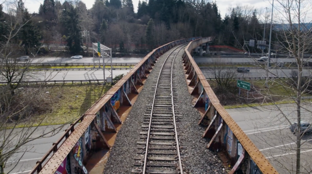
The existing rail bridge. Photo from King County.
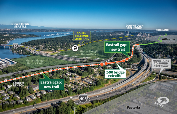
Still from a King County video.

More details from the King County press release:

King County Executive Dow Constantine today thanked U.S. Sen. Patty Murray and U.S. Sen. Maria Cantwell for securing a $25 million federal grant administrated by the U.S. Department of Transportation that will help King County Parks close the final gap of the southern segment of Eastrail by crossing Interstate 90.

King County Parks will use the funds to retrofit a steel bridge that spans 16 lanes of Interstate 90. It is the latest progress for Eastrail, an emerging 42-mile trail that will ultimately connect South and East King County communities to Snohomish County with a spur to Redmond. Executive Constantine and partners recently kicked off a project that will add the 1,000-foot-long Wilburton Trestle to the former rail corridor and on Sunday opened a new trail bridge that connects Eastrail to Sound Transit’s Wilburton Station.

“Senator Murray and Senator Cantwell have delivered a victory for regional trails, climate, mobility, and opportunity,” said Executive Constantine. “The Biden administration appreciates that investing in regional trails creates and connects sustainable, healthy communities with new access to high-capacity transit – and that’s what we will achieve with the RAISE Grant.”

The federal RAISE Grant, administered by the U.S. Department of Transportation, will cover nearly half the total project cost of $49 million, which will build 1.7 miles of new paved trail and create safe connections to the 20-mile Mountains to Sound Greenway trail. Closing the Eastrail gap will provide access to 16 miles of non-motorized trails north through Bellevue and 5 miles south to Renton.

“This major federal investment will help King County close the Eastrail I-90 gap while building out a shared use path that everyone can enjoy,” said Senator Murray. “Every inch of progress so far has been thanks to the partnership of so many: nonprofits, local government, local businesses, and — now — the federal government. Expanding these kinds of trails does so much good for our quality of life while also connecting and strengthening local economies—being able to support these important projects is exactly why I created the RAISE grant program in the first place.”

“The funds announced today are the final link connecting the north and south segments of this beautiful trail, giving Eastside residents a 42-mile pathway to walk and enjoy,” said Senator Cantwell.

U.S. Representatives Suzan DelBene and Adam Smith were also instrumental in advocating for this funding and delivering this grant for King County.

Eastrail will provide direct connections to four of Sound Transit’s 2 Line stations and will be the north-south spine of Leafline, a Central Puget Sound regional trail network that connects King, Pierce, Snohomish, and Kitsap counties.

“With the help of our federal partners, we’re making yet another stride in creating a region-wide, climate-friendly transportation network,” said King County Councilmember Claudia Balducci. “And the timing couldn’t be more fortuitous as we have just opened light rail on the Eastside and the Eastrail NE 8th Street Bridge, recently broken ground on the Wilburton Trestle and will now be able to start work to safely cross I-90, bringing our longtime vision for this 42-mile trail from Woodinville to Renton close to completion. Deepest thanks to the US Department of Transportation for seeing how valuable this trail is to our region and to Eastrail Partners for their help in securing this funding.”

“Throughout my tenure as Co-Chair of the Eastrail Regional Advisory Council we’ve been working hard to close the final gap in the trail network, and with this monumental funding award from USDOT, we are finally able to realize our vision of an uninterrupted 42-mile trail system,” said King County Councilmember Sarah Perry. “This will allow us to continue to connect our vibrant communities across East King County and expand access to our regional parks and open spaces, including King County Conservation Futures acquisitions and partnership on the Mountains to Sound Greenway corridor.”

The nonprofit group Eastrail Partners helps secure public and private funding for the regional trail, which is owned and managed by King County Parks, the cities of Kirkland, Redmond, and Woodinville, Snohomish County, Sound Transit, and Puget Sound Energy.

The City of Woodinville received $5 million in RAISE Grant funding to complete the design, planning, and permitting for its 2-mile segment of Eastrail.

“This exceptional trail requires exceptional community support and partnership to complete,” said Katherine Hollis, Eastrail Partners Executive Director. “This RAISE grant funding for two Eastrail projects – planning funding for the Woodinville section of trail, and capital funding for the I-90 gap project – reflects the exemplary partnerships, enthusiasm, and support that Eastrail Partners has been honored to help build.”

The Interstate 90 trail bridge project will be led by King County Parks, one of four divisions in the Department of Natural Resources and Parks.

Share

#SEAbikes #Seattle

$25M federal grant will help cross final major Eastrail hurdle: I-90

From King County. King County has secured a $25 million federal RAISE grant to rehab an old railroad bridge over I-90 that had been one of the few major pieces still missing from the Eastrail route…

Seattle Bike Blog

NE 8th Street Eastrail bridge opening June 23

Image from King County.

The Eastrail’s NE 8th Street bridge near Wilburton Station in Bellevue is scheduled to open at noon June 23 (Sunday). As we noted when the station first opened this spring, the bridge is a key link to an area that “seems destined to play a special role in connecting biking and transit on Eastside.”

Once open, the trail will extend just a few blocks further south where it will await completion of the iconic Wilburton Trestle rehab project, which broke ground recently. The trestle is anticipated to open in 2026 along with a new I-405 crossing, bringing the trail within reach of Mercer Slough and the I-90 Trail.

Eastrail Partners is hosting a bike ride to the bridge opening that leaves Salt and Straw in Totem Lake at 10:30 a.m. and will stop at Kirkland’s Chainline Station at 11:10 if you want to join partway.

More details on the opening celebration from King County Parks:

On Sunday, June 23, we’ll be holding an opening ceremony for the NE 8th trail bridge in Bellevue, connecting Eastrail to the recently-opened Wilburton light rail station.

Event details:

  • Sunday, June 23, noon (light rail ride at 11:30 a.m.)
  • North side of the bridge: 47°37’07.5″N 122°11’02.0″W
  • Short remarks by elected officials and community partners
  • Photo op of cyclists going over bridge for first time
  • Unveiling of art installation that recognizes the Japanese American farming legacy of that area

Share

#SEAbikes #Seattle

NE 8th Street Eastrail bridge opening June 23

Image from King County. The Eastrail’s NE 8th Street bridge near Wilburton Station in Bellevue is scheduled to open at noon June 23 (Sunday). As we noted when the station first opened this sp…

Seattle Bike Blog

People riding e-bikes and scooters on King County trails are no longer unknowingly breaking the rules

An outlaw riding an e-bike on a King County trail.

Here’s some good news you didn’t know you needed: The King County Council has legalized riding Class 1 and 2 e-bikes as well as electric scooters on the county’s trails. I’m guessing most of you out there had no idea this was not already legal, and e-bike riders have been happily and safely riding there for many years.

The change came as part of a long-awaited major revision of King County Parks rules. Other changes included adding vapes to the definition of a tobacco product and removing a rule that made it illegal to have a picnic except in designated picnic areas. I bet you didn’t know you’ve been having illegal picnics this whole time. In fact, some of you absolute rebels have been illegally riding e-bikes to your illegal picnics. You got away with it, but just barely.

Everything in this story pertains only to trails operated by King County Parks, so it excludes trails operated by other jurisdictions such as Seattle. Seattle allowed e-bikes and scooters on trails years ago, and Seattle-operated trails do not have a mph-based speed limit or hours of operation.

The King County Council added language codifying e-bike classes to mirror state law and mesh with Snohomish and Pierce County rules. They also defined a “micromobility device” as “a personal vehicle meant to carry one or two passengers that has an electric motor and includes electric-assisted bicycles, motorized foot scooters, electric skateboards and other relatively small and lightweight electric devices that provide mobility.” They then exempted “micromobility devices” from the definition of a “motor vehicle.” So what this all means is that you can now ride an e-bike or scooter on trails that do not allow motor vehicles unless signage specifies otherwise. The Parks Director can define specific rules for specific trails at their discretion, but these limitations need to be posted.

The Council did add an interesting exception to the 15 mph trail speed limit rule for mountain biking. Instead, mountain bikers “may not travel at a speed greater than is reasonable and prudent under the conditions with regard to the actual and potential hazards then existing.” I wish this were the rule governing bike speeds on all trails. A mph limit feels like such a car-brained idea that doesn’t really make sense for people on bikes since most bikes don’t have speedometers. 15 is way too fast for congested areas, but it is perfectly safe to ride faster than 15 for many long stretches that are not congested. The language “may not travel at a speed greater than is reasonable and prudent under the conditions” is better because it gets at the behavior we are trying to encourage. Too bad they can’t just post “Speed Limit: Don’t be an asshole.”

Trails, like all King County Parks, technically close at sundown, though this is another rule that essentially nobody follows. Unfortunately, the Council did not change the rules to specifically allow people to use regional trails when it is dark out, though they discussed it. Instead, they passed an ordinance requiring the Parks Department to conduct a “feasibility assessment” by next February for extending trail hours. The assessment should include a list of potential trails and should also consider the importance of trails as transportation connections. They also updated the code to allow the Parks Director to extend trail hours without requiring further Council action and specified that if a person is on a trail the passes through a park, the trail’s open hours apply.

It is absurd for trails to close at sundown since they are transportation facilities. We don’t shut down roads at night, do we? Everybody ignores this rule if they even know it exists. Are we really telling people they should bike on the nearby busy street or highway instead of a peaceful trail whenever it gets dark? Absolute nonsense. It seems like yet another rule designed to harass unhoused people, and I have never heard of anyone getting a ticket for biking on a trail at night (if you have, let me know). The more likely implications are about liability. If trail conditions are unsafe and contribute to a serious bike crash, for example, it may be more difficult for a person’s case to succeed since the county can just say that they were there illegally. But the county should absolutely be responsible for maintaining trails to be safe in dark conditions because it is perfectly reasonable for a trail user to expect them to be safe at all hours. These are transportation facilities and need to be treated as such.

But all this does raise a larger question about how trail rules are governed. Trails are transportation facilities that span multiple jurisdictions just like roads, and it is unreasonable to put the onus on trail users to know when they have a crossed a border and how each jurisdiction’s trail rules differ. I don’t know the best way to do it, but it seems like there should be a way to set basic rules that govern an entire trail network regardless of jurisdiction. It’s ridiculous that someone biking along the Burke-Gilman Trail in Seattle after sundown suddenly becomes an scofflaw as soon as they cross the city limit. From their perspective, nothing has changed.

Nicholas Deshais at the Seattle Times noted one peculiar issue I had never heard of: Trails constructed with federal money cannot allow electric scooters. E-bikes are allowed, but electric scooters will be banned from sections of the East Lake Sammamish and Lake to Sound Trails, at least until the feds update their rules.

Share

#SEAbikes #Seattle

People riding e-bikes and scooters on King County trails are no longer unknowingly breaking the rules

An outlaw riding an e-bike on a King County trail. Here’s some good news you didn’t know you needed: The King County Council has legalized riding Class 1 and 2 e-bikes as well as electr…

Seattle Bike Blog