By the way, I sketched the map with the latest version of my FREE #map / #GIS tool, #GeoSketch v1.2.19. I added rudimentary georeferencing features - and it is totally free, won't even require registration or anything! Use here, or download for local-ish use: jmkorhonen.github.io/geosketch/
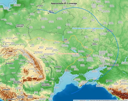
To illustrate what the newest #GeoSketch v1.2 can do - easily! - here's a quick assessment of what that means in practice. It shows ~270 km range "circle" from the front line, which may be a reasonable guess for FP-2 max coverage. #GIS #OSINT See here: jmkorhonen.github.io/geosketch/

RE: https://bsky.app/profile/did:plc:4aqzua5vsewimmusg66fyajl/post/3mmnvp5b3z22h
I updated #GeoSketch to v1.05: it adds the ability to define PNG export area, fixes html export, introduces map notes, and contains other UI tweaks and bug fixes. And did I mention it is totally free to use! No accounts or registrations needed either. Just use it online, or download the index.html.

RE: https://bsky.app/profile/did:plc:l5qgtdxd462q6cz5hbt25edk/post/3mlvqfqzxas23
The #GeoSketch repository can be found here. If you find it useful, give me a follow! github.com/jmkorhonen/g...

GitHub - jmkorhonen/geosketch:...
GitHub - jmkorhonen/geosketch: A single-file, no-installs-required browser tool for quick OSINT map sketching, simple GIS-style visualisation, and lightweight map annotation.

A single-file, no-installs-required browser tool for quick OSINT map sketching, simple GIS-style visualisation, and lightweight map annotation. - jmkorhonen/geosketch

GitHub
BTW I did the map with #GeoSketch, a simple map annotation tool I vibe coded. It does things Google Maps won't, but is much easier to use than proper #GIS software. No installs or registrations needed: run from the live site, or download the index.html for local use. jmkorhonen.github.io/geosketch/