Sovereignty and rising sea levels: Climate change is reshaping the meaning of nationhood

Sovereignty and rising sea levels: Climate change is reshaping the meaning of nationhood
3,400 deaths in a day: India's extreme heat days are deadlier than we imagined
India is being left to die in the heat
Scientists share why moving can be a way for communities to adapt to a warming world. #climatemigration
https://www.carbonbrief.org/experts-why-migration-is-not-a-failure-of-adaptation-in-a-warming-world/

Sea level rise is a direct consequence of human-induced climate change: global warming. It is relentless and very hard to stop. It arises from human-induced warming and the consequential expansion of the ocean, plus the addition of more and more water from melting glaciers and ice sheets. It will continue long into the future.
RT: @CANSouthAsia Samjong village in Nepal now stands empty.
At 3,800m, climate change dried its water sources, forcing 85 people to leave behind their homes, history, and identity.
This is climate displacement, a loss beyond relocation.

‘It’s no longer exceptional’: Karachi struggles under brutal new reality of extreme heat
Close calls at Michigan’s dams are a climate warning to [North] America
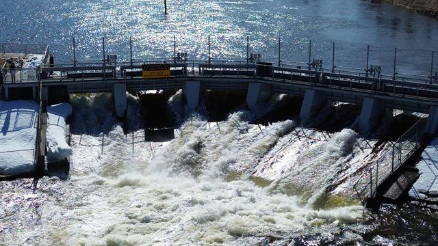
cross-posted from: https://toast.ooo/post/13895382 [https://toast.ooo/post/13895382] > > Flooding across northern Michigan last month pushed rivers to record levels, testing the limits of the state’s aging dams so severely that officials in one city nearly ordered evacuations as water threatened to spill over the top of a key barrier — a close call that highlights the growing risk that intensifying storms pose to similar infrastructure around the country. > > > > Nationwide, the average dam is 64 years old [https://infrastructurereportcard.org/wp-content/uploads/2025/03/Full-Report-2025-Natl-IRC-WEB.pdf] and most were built for rainfall patterns that no longer reflect today’s changing climate. Thousands are classified as high hazard, meaning their failure could result in the loss of life. Dam safety experts say inspections are uneven and improvements often underfunded. > > > > More than half of Michigan’s dams [https://www.michigan.gov/-/media/Project/Websites/egle/Documents/Groups/MDSTF/Report-2021-02-25-Governor-Whitmer.pdf?rev=8e8d11e842c2404fbb077d75c95bdc12] are beyond their 50-year design life, and the risks became clear as snowmelt and weeks of heavy rain swelled rivers. Rising water came within 5 inches of flowing over Cheboygan Dam [https://www.detroitnews.com/story/news/local/michigan/2026/04/17/cheboygan-river-less-than-5-inches-from-dams-top-more-rain-forecast/89649796007/] in Cheboygan, a city of about 4,700 people, on April 16. In Bellaire, officials deployed about 1,000 sandbags to shore up a century-old dam [https://www.interlochenpublicradio.org/podcast/up-north-lowdown/2026-04-16/a-tour-of-the-bellaire-dam-a-narrow-escape-for-road-crews-at-beitner-bridge]. > > > > “This needs to be considered not the worst we can experience. This needs to be considered as typical of the future,” said Richard Rood, a professor emeritus at the University of Michigan who studies climate change. > > > > There are about 92,000 dams [https://www.fema.gov/grants/mitigation/learn/dam-safety/resources-states] in the United States. About 18% are considered high-hazard. The Association of State Dam Safety Officials estimates repairing all of these aging structures will cost more than $165.2 billion [https://damsafety-prod.s3.amazonaws.com/s3fs-public/files/2025%20ASDSO%20Costs%20of%20Dam%20Rehab%20Report.pdf]. In Michigan, that estimate is $1 billion. > > > > Communities facing these risks are left with difficult choices. Given the cost of repairing and upgrading dams to withstand stronger storms, removing them is often cheaper. That can reduce long-term risk and restore rivers [https://grist.org/project/indigenous/klamath-river-dam-removal-tribe-pacificorp-salmon/] to a more natural state. But it often faces resistance from property owners and communities with economies built around the reservoirs those dams created. > > > > As floodwaters recede across Michigan, local leaders, dam safety advocates and experts are renewing calls to bolster safety regulations and deal with aging dams. > > > > [https://slrpnk.net/api/v3/image_proxy?url=https%3A%2F%2Flemmy.ml%2Fapi%2Fv3%2Fimage_proxy%3Furl%3Dhttps%253A%252F%252Fgrist.org%252Fwp-content%252Fuploads%252F2026%252F05%252Fimage.png%253Fquality%253D75%2526strip%253Dall] > > > > Bellaire Dam in Bellaire, Mich. on April 13, 2026 > > Austin Rowlader / IPR News > > > > Bob Stuber, executive director of the Michigan Hydro Relicensing Commission, considers the April flooding a wake-up call and believes the solution is clear: upgrades where feasible and removal where it makes sense. > > > > “I think every opportunity we have to remove an aging dam, we should take advantage of it because it’s not going to get better,” he said. “It’s just going to get worse.” > > > > Officials in Traverse City came to that conclusion in 2024 and removed the Union Street Dam along the Boardman-Ottaway River as part of a decades-long restoration project [https://www.glfc.org/pubs/pdfs/research/Boardman-Ottaway-Report.pdf] that includes FishPass, which will allow key species to pass while blocking harmful invaders like sea lamprey. Engineers said that removal and upgrade most likely reduced flooding impacts when waters surged to near-record levels last month, falling just short of a 500-year flood [https://www.traversecitymi.gov/news/flooding-impacts.html]. > > > > “Upstream would have been under two more feet of water, which would have been quite devastating,” said Daniel Zielinski, a principal engineer for the Great Lakes Fishery Commission. “We actually had a really great stress test of the system. It functioned really well.” > > > > Removals are increasing across the country, according to data from American Rivers [https://www.americanrivers.org/wp-content/uploads/2026/03/DamRemovalCompiledSummaries_2026.pdf]. Since 2000, more dams have come down than gone up, and that pace is accelerating as aging infrastructure, safety concerns, and environmental benefits reshape how communities weigh their value. > > > > In northern Michigan, conservation groups like Huron Pines help dam owners make that decision. It has managed nine removals in the last 13 years and has seen growing interest after the recent flooding, said Josh Leisen, a senior project manager for the organization. Removal reconnects river ecosystems and eliminates the need for expensive upkeep of aging structures, he said. > > > > “There are costs associated with repair and there are risks associated with having a dam,” Leisen said. “Even if it seems to be in good condition, you get extreme weather events like we just had.” > > > > Removing dams is not always straightforward. Beyond the technical challenges, many communities are reluctant to give up the lakes and waterfronts those structures create. > > > > “There’s this emotional attachment to that impoundment,” said Daniel Brown, a climate resilience strategist at the Michigan-based Huron River Watershed Council. > > > > In other cases, dismantling isn’t practical. Some dams provide electricity or drinking water, linking them to local economies and infrastructure. “(Removal) is not really something that’s on the table because they are connected in this very practical way,” Brown said. > > > > Still, Brown said there are limits to how much aging structures can be adapted to a warming world. “(A dam) is this very long-term, huge, expensive infrastructure that you’ve put on the landscape that’s going to stay there. And that is not how climate change or nature or rivers behave,” Brown said. > > > > Dismantling dams, like upgrading them, can come with steep costs. The Boardman-Ottaway River project — which removed three dams in the largest removal effort [https://www.glfc.org/pubs/pdfs/research/Boardman-Ottaway-Report.pdf] in state history — cost $25 million. Huron Pines is managing the removal of Sanback Dam in Rose City next month, at an estimated cost of $4 million. > > > > Half of the expense is funded through a grant program from the Michigan Department of Environment, Energy and Great Lakes, or EGLE, launched in response to the 2020 Edenville Dam failure [https://damfailures.org/case-study/edenville-dam-michigan-2020] which overwhelmed the downstream Sanford Dam. The twin catastrophes forced the evacuation of more than 10,000 residents, destroyed thousands of homes and flooded ecosystems in a disaster that investigators later found was avoidable. The $44 million state program funded several dam removals, upgrades and engineering studies before it ended last year. > > > > A man in a rowboat passes a submerged car in the flooded streets of Sanford, Michigan. [https://slrpnk.net/api/v3/image_proxy?url=https%3A%2F%2Flemmy.ml%2Fapi%2Fv3%2Fimage_proxy%3Furl%3Dhttps%253A%252F%252Fgrist.org%252Fwp-content%252Fuploads%252F2026%252F05%252FMichigan-flooding-dam-failure-upgrades-removal.jpeg%253Fquality%253D75%2526strip%253Dall] > > > > Neil Hawk and his wife Dawn take a rowboat out to a residential part of Sanford to inspect the damage to their neighborhood following extreme flooding throughout central Michigan on May 20, 2020 in Sanford, Michigan. > > Matthew Hatcher / Getty Images > > > > Federal funding is available through [https://www.fema.gov/grants/mitigation/learn/dam-safety] programs administered by agencies such as FEMA [https://www.fema.gov/grants/mitigation/learn/dam-safety/rehabilitation-high-hazard-potential-dams] or U.S. Army Corps of Engineers [https://www.usace.army.mil/Missions/Civil-Works/Infrastructure/Revolutionize/CWIFP/]. But those resources fall short of the estimated $165.2 billion needed to address the issue, and some are at risk of elimination [https://www.eenews.net/articles/house-appropriators-shield-dam-safety-program-from-trump-cuts/]. > > > > State governments regulate roughly 70 percent [https://www.fema.gov/grants/mitigation/learn/dam-safety/resources-states] of the dams in the United States, with the federal government regulating hydropower dams and providing funding and guidance. This means inspection standards, regulations, enforcement, and resources can vary widely. > > > > In Michigan, about 1,000 dams fall under state oversight, while 99 hydroelectric dams are overseen by the Federal Energy Regulatory Commission. The remaining 1,500 are smaller barriers that don’t fit the criteria for state regulation, according to the Michigan Dam Inventory [https://gis-michigan.opendata.arcgis.com/datasets/egle::michigan-dam-inventory/explore]. > > > > Now, state officials are renewing calls for more money and stronger regulations. “Dam safety may be an issue that isn’t partisan,” said Phil Roos, director of EGLE. > > > > Proposed state legislation [https://www.legislature.mi.gov/Bills/Bill?ObjectName=2026-HB-5485] would bolster inspection rules, address private ownership, update design standards, and create more funding opportunities for upgrades or removals. “It’s so important to our state that we can come together, and whether it’s passing the legislation that was proposed, or improving procedures or ultimately funding,” Roos said. > > > > Michigan State Senator John Damoose has expressed concern about private dam ownership since the close call at Cheboygan Dam, which is under both state and private control [https://bridgemi.com/michigan-environment-watch/ownership-disputes-aging-design-add-to-cheboygan-dams-failure-threat/]. About 75 percent of the dams Michigan regulates are privately owned. > > > > “Somebody made a point, ‘Well, we can’t have private companies owning these things.’ I tend to believe in private ownership but they might be right,” Damooose said during a Traverse City roundtable discussion on dam safety. > > > > It’s not just a Michigan issue. Most dams in the United States are privately owned, meaning responsibility for maintenance, upkeep and potential failure falls on individuals, not governmental agencies, according to the Association of State Dam Safety Officials. > > > > Climate change is expected to bring more frequent and intense storms. As the world warms, the atmosphere holds more moisture, fueling more intense precipitation, according to Rood at the University of Michigan. > > > > “Recent flooding “has shown an incredible vulnerability,” he said. “(Dams) are either going to have to be removed or reengineered. Or they’re going to become a set of slowly unfolding failures.” > > > > Luke Trumble, chief of dam safety for Michigan, said the state is already dealing with conditions that many dams were never designed to withstand. > > > > “It’s a little bit of a misconception that if we fix the dam issue, there’ll be no more flooding,” Trumble said. “There’s still going to be flooding on rivers whenever we get rain like this, or rain on snow.” > > > > “What we can do with dam safety legislation is help ensure that flooding is not made worse by a dam failure,” he said.
Corpus Christi Plans to Declare a ‘Water Emergency.’ What Does That Mean?
cross-posted from: https://slrpnk.net/post/37592302 [https://slrpnk.net/post/37592302] > >No modern American city has ever run out of water. But chances are rising that Corpus Christi, Texas, could be the first. Absent a biblical rainfall event, its reservoirs are on track to completely dry up by next year. > > >That raises baffling questions for the future of Texas’ eighth-largest city and one of the nation’s major petrochemical hubs.
‘Point of no return’: New Orleans relocation must start now due to sea level, study finds
>The process of relocating people from New Orleans should start immediately as the city has reached a “point of no return” that will see it surrounded by the ocean within decades due to the climate crisis, a stark new study has concluded. >Ongoing sea level rise and the rampant erosion of wetlands in southern Louisiana will swallow up the New Orleans area within a few generations, with the new paper estimating the city “may well be surrounded by the Gulf of Mexico before the end of this century”. >Low-lying southern Louisiana faces multiple threats, with rising sea levels driven by global heating, compounded by strengthening hurricanes, also a feature of the climate crisis, and the gradual subsidence of a coastline that has been carved apart by the oil and gas industry.