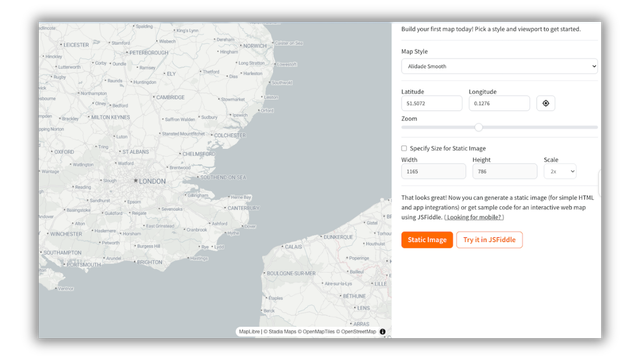
Build your first map today. Pick a style and a viewport to get started.

https://stadiamaps.com/build-a-map/?utm_campaign=build-a-map

Generate a static image (for simple HTML and app integrations) or get sample code for an interactive web map using JSFiddle.

#BuildWithStadiaMaps

We fixed a class of water rendering artifacts in our Interactive Basemaps.

The root cause was that our pipeline was mixing Natural Earth (low zoom) with OSM-derived data at higher zooms. Those datasets don't always agree, and the handoff seam caused visual inconsistencies.

The fix was a single OSM-derived dataset from Overture Maps across all zoom levels. No seam, no artifacts.

#OpenStreetMap #Maps #BuildWithStadiaMaps
https://stadiamaps.com/blog/fixing-missing-water-interactive-basemaps/?utm_campaign=fixing-missing-water-interactive-basemaps

How We Fixed Water Feature Rendering Across All Zoom Levels in Our Basemaps

Mixing Natural Earth and OSM data at different zoom levels caused rivers to vanish, coastlines to shift, and islands to flicker. Here's how we unified our basemaps around a single Overture Maps dataset to fix it.

Stadia Maps

Continuing our popular docs series with the Map Style Library.

8 styles to pick from: Alidade Smooth for data-heavy maps, Alidade Smooth Dark for the dark mode crowd, satellite imagery, Outdoors for trails and terrain, and the beloved Stamen classics (Toner, Terrain, Watercolor). Can't find a perfect fit? There's a custom styling path too.

All styles available on our free tier.

#OpenStreetMap #MapLibre #BuildWithStadiaMaps
https://docs.stadiamaps.com/themes/?utm_campaign=docs-series-map-styles

Map Style Library - Stadia Maps Documentation

Find your map style. Stadia Maps offers a variety of map styles to suit different applications. Use our style library to help you find the right one.