#NIFC #wildfires #firewx
NIFC New Or Updated Wildfire Perimeter
Incident Name: Blue Hills
Acres: 3899.8 acres
Updated: Feb 04, 2025 02:29 UTC
Source: IRWIN
#BlueHillsFire #TXwx
#NIFC #wildfires #firewx
NIFC New Or Updated Wildfire Perimeter
Incident Name: Blue Hills
Acres: 3899.8 acres
Updated: Feb 04, 2025 02:29 UTC
Source: IRWIN
#BlueHillsFire #TXwx
#NIFC #wildfires #firewx
NIFC New Or Updated Wildfire Perimeter
Incident Name: Blue Hills
Acres: 3868.0 acres
Updated: Feb 03, 2025 22:19 UTC
Source: IRWIN
#BlueHillsFire #TXwx

"On 2/1/2025, At approximately 1:00 pm, a wildfire was reported in Moore county East of FM 1913 and North of Blue West Rd. SW winds are pushing the fire NE. Evacuations have been made for campgrounds at Lake Meredith National Park and residents of Bugbee. Texas A&M Forest Service was requested at 1:16, and is working in unified command with Moore County and National Parks Services. "

#BlueHillsFire #TXwx #wildfire

https://m.ai6yr.org/@inciweb_bot/113930765780048748

Inciweb Bot (@[email protected])

#wildfire #inciweb #ncwg TXTXS Blue Hills Fire Last updated: --- The type of incident is Wildfire and involves the following unit(s) Texas A&M Forest Service. --- State: Texas --- Coordinates: Latitude: 35° 42 0342 Longitude: 101° 39 2364 --- NOTE: All fire perimeters and points are approximations. --- Incident Overview: On 2/1/2025, At approximately 1:00 pm, a wildfire was reported in Moore county East of FM 1913 and North of Blue West Rd. SW winds http://inciweb.wildfire.gov/incident-information/txtxs-blue-hills-fire

AI6YR's Mastodon
Hutchinson County, TX: "An uncontrolled wildfire has jumped Blue West at Lake Meredith and is approaching Bugbee community. The fire is moving northeast. All persons in the area should take emergency precautions NOW!" #TXwx #wildfires #LakeMeredith #Bugbee #BlueHillsFire

Smoke from the Canton Reservoir Pond fire, today Monday afternoon Oct 18th, photographed from Buck Hill.

Not what I was hoping to see today! From what I have learned, this fire stated the previous day and is somewhat contained at this point, but still smoldering.

#buckhill #bluehills #bluehillsfire #bluehillsreservation #boston #BostonMA #Canton #CantonMA #CantonReservoir #CantonReservoirPond #CantonReservoirFire

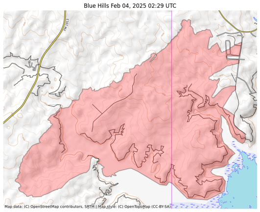
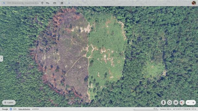
Google Earth imagery of Buck Hill from June 3rd, 2024.

This photo is quite remarkable in that it clearly shows the remnants of the Buck Hill fire that occurred on April 27th, 2024, about five weeks prior. North is to the left. I orientated the image such that The Skyline Trail runs from top to bottom. One can clearly see that the fire devastated the north side of the hill. It seems to have burned right up to the Skyline trail and then somehow stopped. Did this happen because firefighting crews were able to get up that trail and establish a barrier? Or was it simply a case where the fire could not jump the trail, which is fairly wide? This photo also shows how lightly forested the top of Buck Hill actually is.

#GoogleEarth #buckhill #buckhillfire #bluehills #bluehillsfire #bluehillsreservation #boston #BostonMA #MiltonMA #RandolphMA #QuincyMA