@SeismoTrack

0 Followers
0 Following
201 Posts

SeismoTrack delivers real-time earthquake alerts worldwide. Get instant updates with epicenter maps, quake magnitude, and potential impact analysis โ€” powered by live seismic data.

Stay informed. Stay prepared.

Telegramhttps://t.me/+JqdtAtcQ2uc0NDg0

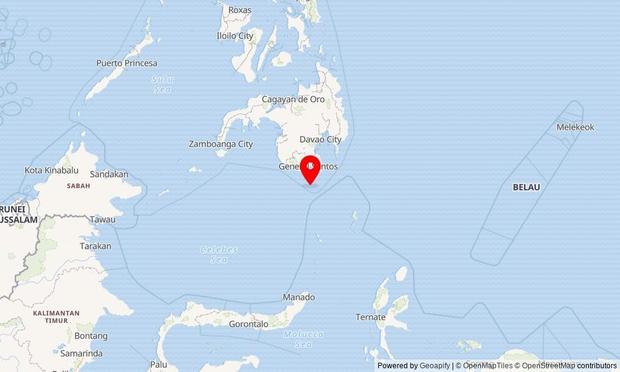
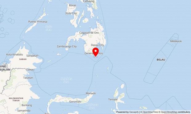
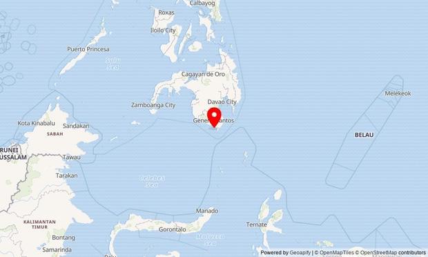
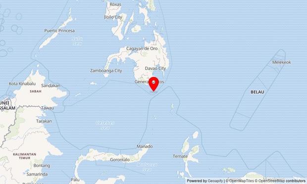
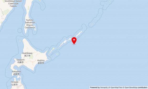
Magnitude 5 earthquake near 21 km SW of Balangonan, Philippines

Date: 2026-06-10
Time: 11:07:56 UTC
Location: ๐Ÿ‡ต๐Ÿ‡ญ Philippines

This quake occurred due to movement along the Philippine Fault System, common in this seismically active region. The depth of 36.5 km suggests it originated in the upper crust.

https://www.google.com/maps/@5.4152,125.2355,6z

#Earthquake #Seismology #SeismoTrack #Philippines

Magnitude 5.7 earthquake near 33 km ESE of Olโ€™ga, Russia

Date: 2026-06-10
Time: 10:34:17 UTC
Location: ๐Ÿ‡ท๐Ÿ‡บ Russia

This quake occurred in the far east of Russia, likely due to movement along the Pacific Ring of Fire. The deep focus (343 km) suggests it was caused by subduction zone activity.

https://www.google.com/maps/@43.6289,135.6736,6z

#Earthquake #Seismology #SeismoTrack #Russia

Magnitude 5.1 earthquake near 7 km NW of Nuing, Philippines

Date: 2026-06-10
Time: 09:13:42 UTC
Location: ๐Ÿ‡ต๐Ÿ‡ญ Philippines

This quake occurred due to movement along the Philippine Fault System, common in this seismically active region. The depth of 61.7 km suggests it originated in the upper mantle.

https://www.google.com/maps/@5.6757,125.3874,6z

#Earthquake #Seismology #SeismoTrack #Philippines

Magnitude 5.1 earthquake near 11 km WSW of Sardinal, Costa Rica

Date: 2026-06-10
Time: 03:01:35 UTC
Location: ๐Ÿ‡จ๐Ÿ‡ท Costa Rica

This quake occurred along the northern edge of the Nazca Plate, caused by shallow crustal deformation. No tsunami warning issued.

https://www.google.com/maps/@10.4644,-85.7378,6z

#Earthquake #Seismology #SeismoTrack #CostaRica

Magnitude 5 earthquake near 6 km WSW of Burias, Philippines

Date: 2026-06-10
Time: 01:54:24 UTC
Location: ๐Ÿ‡ต๐Ÿ‡ญ Philippines

This quake occurred due to tectonic stress in the Philippine Sea Plate. It is likely related to shallow crustal adjustments in the region.

https://www.google.com/maps/@5.697,125.1975,6z

#Earthquake #Seismology #SeismoTrack #Philippines

Magnitude 6 earthquake near Auckland Islands, New Zealand region

Date: 2026-06-10
Time: 00:44:20 UTC
Location: ๐Ÿ‡ณ๐Ÿ‡ฟ New Zealand region

This quake occurred at a depth of 9.5 km, likely caused by crustal deformation along the Pacific Plateโ€™s edge. No immediate tsunami threat reported.

https://www.google.com/maps/@-49.6544,164.0861,6z

#Earthquake #Seismology #SeismoTrack #NewZealandregion

Magnitude 5 earthquake near Sarangani, Philippines

Date: 2026-06-09
Time: 23:14:43 UTC
Location: ๐Ÿ‡ต๐Ÿ‡ญ Philippines

This quake occurred due to movement along the Philippine Fault Zone, a seismically active region caused by the collision of tectonic plates. The depth of 64.1 km suggests it originated in the upper mantle.

https://www.google.com/maps/@5.3722,125.4727,6z

#Earthquake #Seismology #SeismoTrack #Philippines

Magnitude 5.2 earthquake near 163 km ESE of Petropavlovsk-Kamchatsky, Russia

Date: 2026-06-09
Time: 19:49:03 UTC
Location: ๐Ÿ‡ท๐Ÿ‡บ Russia

This quake occurred in a seismically active region of the Kamchatka Peninsula, likely due to movement along the Pacific Ring of Fire. The shallow depth (10 km) suggests it may be related to crustal deformation near subduction zones.

https://www.google.com/maps/@52.3674,160.7499,6z

#Earthquake #Seismology #SeismoTrack #Russia

Magnitude 5.1 earthquake near southeast Indian Ridge

Date: 2026-06-09
Time: 19:36:10 UTC
Location: ๐Ÿ‡ฎ๐Ÿ‡ณ India

This quake occurred along the southeast Indian Ridge, a mid-ocean ridge where tectonic plates are spreading apart. The shallow depth suggests it was caused by fault movement in the upper crust.

https://www.google.com/maps/@-41.5157,84.9096,6z

#Earthquake #Seismology #SeismoTrack #Ridge

Magnitude 5.1 earthquake near 120 km ESE of Kurilโ€™sk, Russia

Date: 2026-06-09
Time: 19:25:35 UTC
Location: ๐Ÿ‡ท๐Ÿ‡บ Russia

This quake occurred in a seismically active region of the Kuril Islands, likely due to subduction zone activity between the Pacific and Okhotsk plates. Moderate shaking may be felt in nearby populated areas.

https://www.google.com/maps/@44.8123,149.2865,6z

#Earthquake #Seismology #SeismoTrack #Russia