Today I am starting a series of posts on recent lunar missions. We have had a few since my previous Moon sequence. But I will start with a correction to part of my previous set - it's Luna 20. andr59 - this is for you! Looking back, I was puzzling over the locations of the horizon details as I was posting, and I could tell something was wrong. I found that my assembly of the panorama was wrong - my pal Ted Stryk had been right all along.
How do these things happen? The sources are inconsistent. Look at this image I scanned in Moscow. It shows the 2 horizon fragments seen by Luna 20. It turns out the top one is reversed but the bottom one is not. I reversed both and as a result the rod-like structure did not fit with one in another fragment, so had to be different. Now I have it figured out at last. Tomorrow, the pan as it should be.
#moon #luna20
#moon #luna20

Here is my new version of the panorama. I don't know why I didn't see it earlier, but such is the stubbornness of the human mind (or mine anyway). Is that gap real? One dark spot looks like it may be repeated across the gap but I don't see anything else to give me confidence. The really annoying thing is that the original mission team never published a full panorama.
Next - can we reliably identify any of these features in LRO images?

This is the southern end of the Luna 20 panorama tilted to make the horizon horizontal. I have tried several times to match these features with LRO images, but it's not easy. The white shape at right is part of the lander. in Quickmap's 3D view I swooped down on the lander to look for features resembling these. Let's take a look...
#moon #luna20
#moon #luna20

Here is a Quickmap 3D image looking south from the lander, which is the dark spot at bottom. So this is from a bit too high but lets us see the landscape. Let's go a bit lower...
#moon #luna20
#moon #luna20

The lighting in the 3D view is different from the Luna 20 image which doesn't help. This view is from a lower elevation. The dark foreground spot is the shaded side of a crater just beyond the lander in the previous view. A near horizon slopes down to the left, but in the tilted panorama a similar feature tilts down to the right. Is the whole panorama reversed now? Matching the landscape should be possible but I haven't got it right yet. I don't know anyone else who has tried.

Let's consider the possibility that the whole Luna 20 panorama I posted is in fact reversed left-right. Does that make any sense? Does it mean those distant hills are north of the lander instead of south? No, because Russian sources have always said that the distinctive crater at one end of the panorama is north of the lander. The hills have to be south, and that means the middle of the panorama faces west instead of east as I had assumed in the past. Let's take a look...
#moon #luna20
#moon #luna20
Here is the panorama looking west in the middle (the sun is high in the sky so shadows don''t help much). The left end with the hills looks south, the right end with the crater looks north. Now the distant hills, when tilted as at lower left, do look more like the Quickmap view. It's not a perfect match. Are lighting differences to blame? Or is that another way we can fool ourselves? Tomorrow we will look at this in map view and try to make sense of it that way.
#moon #luna20
#moon #luna20

To recap, here is the reversed panorama with a version projected to make the horizons at each end horizontal, and enlarged views of the horizon segments. The high sun makes features difficult to see, but I have marked a crater close to the lander, imaginatively naming it 'close crater'. Can we find it on a map?
#maps #moon #luna20
#maps #moon #luna20

This map of the area immediately around the lander shows the scenario I am considering. Unlike a version I posted previously, the panorama is now on the west side of the lander. There is a crater which could correspond with 'close crater'. Other craters just north and southwest of the lander would be partly visible but the panorama is basically featureless in those areas, maybe because of the high sun. If the pan is east of the lander there is no 'close crater'.
#maps #moon #luna20
#maps #moon #luna20

Tomorrow we will look out towards the horizon and try to match more distant features. In the map just posted I say the northern crater is unidentified - but will I feel the same tomorrow? It's an emotional roller-coaster, but all will be revealed... or will it?
OK, time to look out to the horizon and identify distant features. Here is the view to the south from Luna 20 compared with an LRO image. labels identify features I think match up between them. I have tried this several times but I think this works better than any other version. If only the original researchers involved in the mission had done their own analysis of the images, but I have never seen anything like that.
#moon #luna20
#moon #luna20

Looking north with synthetic Quickmap 3D views makes it clear that the 'northern crater' I had trouble matching with the panorama before I flipped it can in fact be identified. Here it is, about 60 m north of the lander and about 10 m across. Small craters near it match up well to prove it. I am now convinced that the flipped panorama I have shown here is correct.
On to something new tomorrow, a recent moon lander.
#maps #moon #luna20

I had a thread on lunar landing sites a year or so ago, which is included in the 'planetary mapping' PDF linked in the pinned post thanks to @birchbirch. This current thread is an update, so here I am continuing where that thread finished, just leading up to Chang'e 6. Here are 2 maps for context. They show the defined landing area and a backup area further west. A specific landing box was defined within the large landing area later.

Many craters are named here. China has been quite active in getting names approved around its landing sites. You can also see craters commemorating several US astronauts (see the ALT text in the previous post) including the Columbia crew and 2 of the Apollo 1 crew. The Challenger crew are commemorated by craters north of here, and Soviet astronauts have their own craters near Tsiolkovskiy and Mare Moscoviense.
#moon #change6
#moon #change6
Here I zoom in on the Chang'e 6 landing site. I have done this 4 frame sequence for every landing and crash site which we can identify in LRO images. The second image shows the specific target box in the larger landing area. They landed almost in the middle of it. It looks like a typical mare surface but it's anything but. This was only the second landing on the far side of the Moon and the first sample return.

So this is a farside mare (basalt lava flow) and the regolith developed on that lava flow contains fragments thrown onto it from distant craters. The young crater Chaffee S (shown yesterday) is a likely source of some of those fragments. They would include samples of the South Pole-Aitken Basin floor, a prize long desired by lunar scientists.
#moon #change6
#moon #change6
We landed! Let's take a look around the Chang'e 6 landing site. The sample return landers only took half a panorama, alas. Here:
https://english.www.gov.cn/news/202406/04/content_WS665ec2d7c6d0868f4e8e7d12.html
are some images including their panorama (second image). My version has a straightened horizon (it's a cylindrical projection). Below is a closeup of hills on the horizon, the rim of Chaffee crater. I will eventually fill the bit at the top where the flag is to maximize the surface view.
#moon #change6

In this view I have projected the panorama into a semicircle with north at the top (the process exaggerates horizon relief). I also massaged the scene a little bit to make visible the 50 m subdued crater whose rim the spacecraft landed on. Otherwise it is very difficult to discern.
#moon #change6
#moon #change6

That Chang'e 6 panorama was not the only image from the mission. The spacecraft had multiple cameras to monitor activities throughout surface and orbital operations, but the one which got most attention was on a tiny rover:
https://www.planetary.org/space-images/change-6-surprise-rover
It was dropped off the side of the lander and could operate whichever way up it landed. More details:
https://www.leonarddavid.com/up-close-look-at-chinas-change-6-mini-rover/
That link shows a picture taken by the rover. Quite impressive!

Less well known is this second image which appeared on a social media site which I can't get back to. But I save everything... This was taken earlier, closer to the lander. The hills in the background of both images of the lander are parts of Mons Song, south of the lander in a map I posted earlier.
#moon #change6
#moon #change6

This video:
https://www.youtube.com/watch?v=svW5JNPAD6c
shows the Chang'e 6 sampling process. First a drill, which took a c. 100 cm core. It should have gone to 200 cm but hit a rock. Then a scoop which collected 8 scoops of regolith. Three times the scoop contacted the surface before digging (C1, C2, C3), to calibrate the position of the scoop. Later the data from the contacts was used to measure surface strength. The process was fully automated.
#moon #change6

Time to put everything together for Chang'e 6. Here is a map of the immediate area of the lander. I need to confirm the location of the drill. The Lunar Mineralogy Spectrometer (LMS) did multispectral mapping of the sampling area to help find a good place to scoop. Some parts were looked at in more bands (hyperspectral), observing traces of water (top right inset). The rover route is mapped but I am still waiting for a formal paper on it for details.
#moon #change6
#moon #change6

I am compiling a history of lunar exploration which organizes missions by launch date. For the first time my scheme ran into difficulty his year when Firefly's Blue Ghost Mission 1 and ispace's Hakuto-R Mission 2 were launched on the same Falcon 9. I will look at the Firefly mission first and the ispace mission next as they reached the Moon in that order.
Firefly Aerospace's lander 'Blue Ghost' takes its name from a kind of firefly...
#moon #CLPS #firefly #BGM1
... The Firefly lander originated as the lander called Beresheet or Genesis, flown by the Israeli company SpaceIL in 2019. It crashed. Firefly modified the design and built it in the US to ensure it was eligible for NASA funding. OK, we have a lander - now, where is it going to land?
This CLPS (Commercial Lunar Payload Services) mission grew out of studies for a lunar geophysical network which wanted one node in Mare Crisium.
This map starts with 2 sites in Mare Crisium (map A). B and C show the 2 sites. In D several possible locations near the small volcanic hill Mons Latreille are shown, with further details in E, F and G. The site shown in G was chosen for the landing. This site had to be relatively smooth with few rocks, and not in a magnetic anomaly with a stronger magnetic field to suit one of the instruments.

What we saw yesterday might be called the official site selection process for Firefly's first lander. But there's more to the story. Often people outside the mission offer suggestions as well, and here we see work by Mélissa Martinot and colleagues looking at alternatives. The work was presented at the European Lunar Symposium in Dumfries, Scotland, in June 2024. The top map here shows the region with 7 suggested sites, with more detail below.
#moon #CLPS #firefly #BGM1
#moon #CLPS #firefly #BGM1
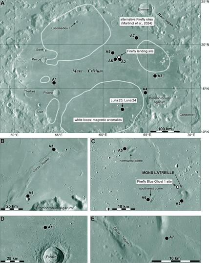
The map of Mare Crisium shows the magnetic anomaly areas which were to be avoided. Also shown is the Luna 23/Luna 24 site and the actual Firefly site.
Next we will start to zoom in on this landing site. Firefly's Blue Ghost Mission 1 (BGM1) was also given its own name, Ghost Riders in the Sky. We can hum along as we descend.
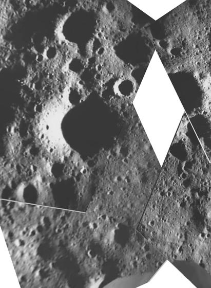
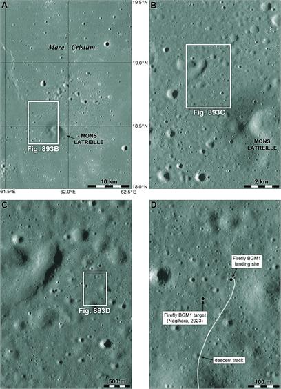
Here is one of my trademark zoom-in sets of images to help locate the Firefly BGM1 landing site. It's quite close to and northwest of a small breached volcanic cone called Mons Latreille. The cone is visible from the landing site but we didn't get a full panorama from the lander (or haven't seen one yet) so we only have a partial view of it. The lower right image shows the descent track meandering up from the south.
#moon #CLPS #firefly #BGM1
#moon #CLPS #firefly #BGM1
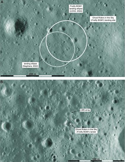
Two more maps take us down to the BGM1 lander. The top image is from LRO, the bottom one is made of spacecraft descent images, using the LRO image as a base to get the geometry right. In the top image the lander and its shadow are visible. In the lower map the lander is drawn in with its LMS (Lunar Magnetotelluric Sounder) array around it. Four projectiles were fired by springs out to about 20 m from the lander, trailing wires which form antennae for the experiment.
#moon #CLPS #firefly #BGM1
#moon #CLPS #firefly #BGM1
Firefly landed successfully and operated flawlessly (as far as I can tell), as I am sure you all know. Here is the Firefly web page for the mission:
https://fireflyspace.com/missions/blue-ghost-mission-1/
and here is their image and video site:
https://www.flickr.com/photos/fireflyspace/albums/72177720313239766/
It's nice to look back at the landing video and others here. We have had some failed and partially successful landings in recent years - let's hope for more successes in future.
Here is a quick 'storyboard' summary image.
#moon #CLPS #firefly #BGM1
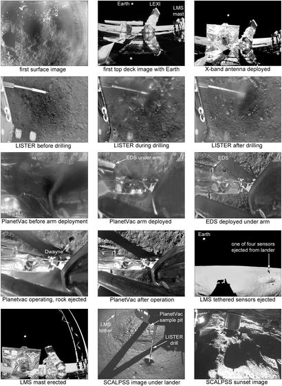
Planetvac ejected a rock - and yes, it was named Dwayne. Not sure why... The SCALPSS image under the lander shows the LISTER drill hole, and beside it a pit with coarser material in the middle... I have labelled it as caused by the Planetvac sampling but it could be from the landing thrusters. Any ideas? I'm waiting for papers on the SCALPSS and Planetvac experiments which I hope will fill in a lot of details.
#moon #CLPS #firefly #BGM1
#moon #CLPS #firefly #BGM1
I really want to have two more maps for Firefly's BGM1 mission: an improved version of what I am showing here and a further enlargement showing the space under the lander, locating the drill, Planetvac and other experiment locations, the surface changes created by the landing etc. They have to wait for future publications or presentations. This is a quick version of a map made from SCALPSS (Stereo Cameras for Lunar Plume Surface Studies) images as released so far.
#moon #CLPS #firefly #BGM1
#moon #CLPS #firefly #BGM1