Looks like it’s been raining at home quite a bit, another half an inch in the last 24 hours with more coming. Big storm last week brought tornados to Woodstock and Lincoln Vermont.
#NHwx #VTwx
https://www.pressreader.com/usa/the-boston-globe/20260620/281741276129295
Tornado WATCH posted by NWS Gray until 7 PM for Androscoggin, Cumberland, Franklin
Oxford, And York counties in #Maine and all of New Hampshire : https://forecast.weather.gov/wwamap/wwatxtget.php?cwa=GYX&wwa=tornado%20watch #MEwx #NHwx
NWS Gray Emergency Managers Self-brief for Thursday AM: Rain giving way for potential severe thunderstorms this evening. Strong winds, flooding in mountains the primary threats. Flood WATCH from noon until this evening for higher elevations in New Hampshire and Maine: https://forecast.weather.gov/wwamap/wwatxtget.php?cwa=GYX&wwa=flood%20watch #MEwx #NHwx #MEweather
NWS Gray Emergency Managers Self-brief for Wednesday PM: Increasing chance of severe thunderstorms on thursday afternoon bringing damaging wind gusts to 55 MPH and downpours tomorrow; continued risk of coastal flooding at overnight high tide. Mountain valleys should be alert for localized flash flooding. Coastal Flood STATEMENT: https://forecast.weather.gov/wwamap/wwatxtget.php?cwa=GYX&wwa=coastal%20flood%20statement #MEwx #NHwx #MEweather
NWS Gray Emergency Managers Self-brief for Sunday PM: Threat of severe storms and heavy rain from cold front approaching this evening extended farther east. Threat of high winds and hail from isolated thunderstorms; 2-3 inches of rain creates risk of localized flash flooding. Flood WATCH through Monday morning for western Maine and northern New Hampshire: https://forecast.weather.gov/wwamap/wwatxtget.php?cwa=GYX&wwa=flood%20watch #MEwx #NHwx #MEweather
NWS Gray Emergency Managers Self-brief for Sunday AM: Cold front this evening brings portntial for isolated severe thunderstorms, localized flooding. Coast should be alert for minor flooding from high tide +rain; Flood watch inland. Coastal Hazards ADVISORY: https://forecast.weather.gov/wwamap/wwatxtget.php?cwa=GYX&wwa=coastal%20flood%20advisory #MEwx #NHwx #MEweather
Biked with wife today, following gravel roads up a lot of hills and by a few remote lakes to Danbury then some rail trail. Not the best temperatures for that much climbing and she forgot to charge her bike. It was a slow crawl towards the end. ":^)
#BikeTooter #NHwx
Noticed yesterday afternoon that we hit a foot of rain so far this year. Drought monitor website puts us round around the border of Abnormally Dry and Moderate Drought, which is much better than recent years.
#NHwx
I didn't have high hopes for this morning's ride, it was already in the 70's (F), humidity in the 90's, and a brutal sun. Turned out the random route mostly followed streams down shady gravel roads, while helpful clouds shaded the sun in the open spots. 9/10 would do again.
#NHwx #BikeTooter #Turtles

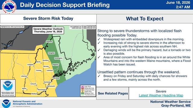
#NWS #flood #nwsflashflood #FlashFloodWarning Flash Flood Warning for Carroll, NH; Grafton, NH #NHwx
FFWGYX

The National Weather Service in Gray has issued a

* Flash Flood Warning for...
East Central Carroll County in northern New Hampshire...
East Central Grafton County in northern New Hampshire...

* Until 345 AM EDT.

* At 1233 AM EDT, Doppler radar indicated thunderstorms producing
heavy rain across the warned area. Between 1 and 3 inches of rain
have fallen. The expected rainfall rate is 1 to 2 inches in 1
hour. Flash flooding is ongoing or expected to begin shortly.

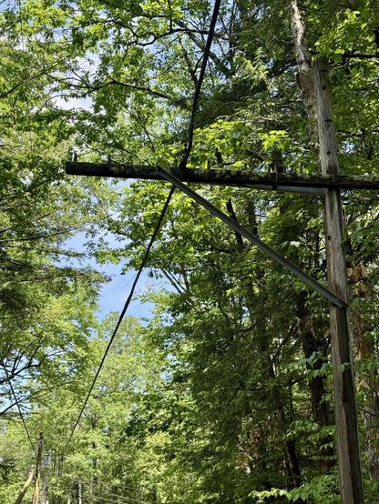
HAZARD...Flash flooding caused by thunderstorms.

SOURCE...Radar.

IMPACT...Flash flooding of small creeks and streams, urban
areas, highways, streets and underpasses as well as
other poor drainage and low-lying areas.

* Some locations that will experience flash flooding include...
Conway, Lincoln, Ossipee, Effingham, Tamworth, Sandwich,
Woodstock, Bartlett, Madison and Freedom.