Red notification for tropical cyclone SINLAKU-26. Population affected by Category 1 (120 km/h) wind speeds or higher is 52601 .

From 09/04/2026 to 15/04/2026, a Hurricane/Typhoon > 74 mph (maximum wind speed of 287 km/h) SINLAKU-26 was active in NWPacific. The cyclone affects these countries: Northern Mariana Islands, Guam (vulnerability Medium). Estimated population affected by category 1 (120 km/h) wind speeds or higher is 52601 . #weather #supertyphoon #Sinlaku #Guam #Marianas
https://www.gdacs.org/report.aspx?eventtype=TC&eventid=1001270

Super Typhoon Sinlaku batters remote U.S. islands with ferocious winds
A super typhoon steadily battered a pair of remote U.S. islands in the Pacific Ocean with ferocious winds and relentless rains, shredding tin roofs and forcing residents to take cover from flying tree limbs.
https://www.cbc.ca/news/world/super-typhoon-sinlaku-pacific-islands-9.7163755?cmp=rss
It looks like Saipan may be having a rough time with the super typhoon right now. Hopefully everyone is safe.

Such a beautiful island above and below the water. Here's an eagle ray from my dive trip there.

#saipan #supertyphoon #sinlaku #typhoon #weather #nature #ocean #marianas #underwaterphotography #eagleray

#weather #supertyphoon #Guam

GU - Tropical Storm Warning

Severity: Severe
Starts: 4/13/2026, 8:17:00 PM
Expires: 4/14/2026, 4:30:00 AM

Location: Guam

...EXTREMELY DANGEROUS SUPER TYPHOON SINLAKU MOVING NORTHWEST AND WILL MOVE OVER TINIAN AND SAIPAN TONIGHT... .NEW INFORMATION... None. .AREAS AFFECTED... This local statement provides important information and recommended actions for people in Guam and the Northern Marianas. .WATCHES/WARNINGS... A Typhoon Warning continues for Rota, Tinian, and Saipan. A Typhoon Warning continues effect for Alamagan, Pagan, and Agrihan. A Tropical Storm Warning and a Typhoon Watch continues for Guam. A Flood Watch is in effect for all of Guam and the Northern Marianas. Please listen closely for any Flood Warnings that might be in effect for your area. Please check the latest public and marine forecasts for detailed information about additional hazards. .STORM INFORMATION... At 1 PM ChST...the center of Super Typhoon Sinlaku (04W) was located near latitude 14.5N...longitude 146.2E. This was about 100 miles east-northeast of Guam, 45 miles southeast of Tinian, and 50 miles southeast of Saipan. Storm motion was northwest, 320 degrees, at 9 mph. Storm intensity was 155 mph. .SITUATION OVERVIEW... Super Typhoon Sinlaku (04W) continues to move northwest toward the Marianas, with the outer eye wall approaching Tinian and Saipan and rainbands continuing to move over Guam. The most recent storm track produced by the Joint Typhoon Warning Center (JTWC) continues to favor the center of Sinlaku passing over Tinian and Saipan as a destructive Category 4 typhoon.

People should be in a designated shelter or in a sturdy and reinforced concrete building to ride out the storm as tropical storm force winds are occurring and will be increasing through the day. Due to the size of the storm, tropical storm force winds are expected to continue into Wednesday night. Even when winds start to decrease, remain indoors until the government of Guam gives the "all clear".

https://wxwarn.affirmatech.com/

WXWarn

Track severe weather now, anywhere in the US with WXWarn!

Super Typhoon Sinlaku nears Saipan and Tinian with destructive winds, flooding and dangerous surf

Super Typhoon Sinlaku approached Saipan and Tinian on April 14, 2026, with destructive typhoon-force winds, life-threatening coastal flooding and torrential rain expected through Wednesday. The National Weather Service said the storm’s center was just southeast of the islands Tuesday afternoon local time, with the eyewall nearing both islands and dangerous conditions already affecting parts of the Marianas. #weather #supertyphoon #Sinlaku #Saipan #Tinian
https://watchers.news/2026/04/14/super-typhoon-sinlaku-saipan-tinian-destructive-winds-flooding-dangerous-surf-april-14-2026/

Super Typhoon Sinlaku nears Saipan and Tinian with destructive winds, flooding and dangerous surf

Super Typhoon Sinlaku approached Saipan and Tinian on April 14, 2026, with destructive typhoon-force winds, life-threatening coastal flooding and torrential rain expected through Wednesday.

The Watchers

If there's anyone on Saipan or Tinian on the Fediverse...
(kinda doubt it)

https://m.ai6yr.org/@easwatch/116401374159255760

#supertyphoon

EAS Watcher (@[email protected])

Attached: 1 image #EAS #WEA for Saipan, #MP; #Tinian, #MP: National Weather Service: An EXTREME WIND WARNING is in effect for this area for the immediate danger of life-threatening winds til 6:15 PM ChST. Take cover NOW in an interior room of a sturdy building, away from windows. Protect your head from flying debris. Do NOT go out in the calm of the hurricane eye! Winds will quickly become dangerous again. Source: NWS Tiyan GU ** DO NOT RELY ON THIS FEED FOR LIFE SAFETY, SEEK OUT OFFICIAL SOURCES ***

AI6YR's Mastodon
Today we check in on Super #Typhoon #Sinlaku the strongest tropical cyclone on Earth so far in 2026, approaching #Tinian and #Saipan in the Mariana Islands #supertyphoon #typhoonsinlaku #YouStormOutlook https://youtu.be/b01mqIPyYF4
Super Typhoon Sinlaku threatens Marianas 2026 strongest so far

YouTube
Explosive Category 5 Monster: The Typhoon Sinlaku Targeting Marianas Guam

As Super Typhoon Sinlaku heads for Guam, residents brace for impact. Stay informed about the storm's intensity and path.

Severe Weather Europe

2025 was one of three hottest years on record, scientists say

By Alexa St. John
Dec. 30, 2025 6 AM PT

"#ExtremeWeather events kill thousands of people and cost billions of dollars in damage annually.

"#WWA scientists identified 157 extreme weather events as most severe this year, meaning they met criteria such as causing more than 100 deaths, affecting more than half an area’s population or leading to a state of emergency being declared. Of those they closely analyzed 22.

"That included dangerous #HeatWaves, which the WWA said were the world’s deadliest extreme weather events this year. The researchers said some of the heat waves they studied were 10 times more likely than they would have been a decade ago because of #ClimateChange.

" 'The heat waves we have observed this year are quite common events in our climate today, but they would have been almost impossible to occur without human-induced climate change,' Otto said. 'It makes a huge difference.'
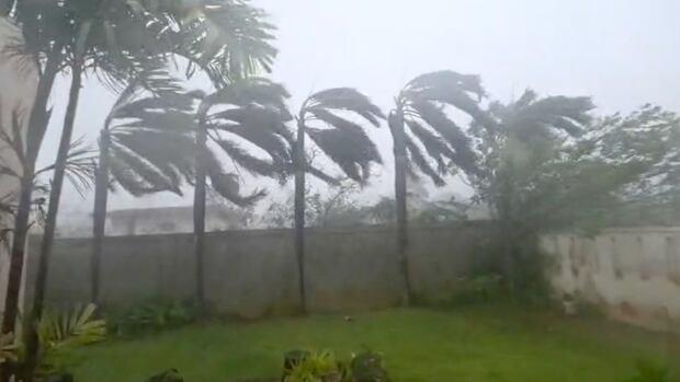
Prolonged drought contributed to #wildfires that scorched #Greece and #Turkey. Torrential rains and #flooding in #Mexico killed dozens of people and left many more missing. #SuperTyphoon #FungWong slammed the #Philippines, forcing more than a million people to evacuate. #Monsoon rains battered #India with floods and landslides.

"The WWA said the increasingly frequent and severe extremes threatened the ability of millions of people across the globe to respond and adapt to those events with enough warning, time and resources, what the scientists call 'limits of adaptation.' The report pointed to #HurricaneMelissa as an example: The storm intensified so quickly that it made forecasting and planning more difficult, and pummeled #Jamaica, #Cuba and #Haiti so severely that it left the small island nations unable to respond to and handle its extreme losses and damage. "

Read more:
https://www.latimes.com/environment/story/2025-12-30/2025-was-one-of-three-hottest-years-on-record

Archived version:
https://archive.ph/AIdsN

#ClimateCrisis #ExtremeWeather #FossilFuels #FossilFools #Oiligarchy #MakeCorporationsPay!

2025 was one of three hottest years on record, scientists say

Climate change worsened by human behavior made 2025 one of the hottest years ever recorded. There were 157 "most extreme" weather events.

Los Angeles Times

Public warned of ‘fake’ posts about weather disturbance that may become ‘super typhoon’

https://web.brid.gy/r/https://interaksyon.philstar.com/rumor-cop/2025/11/13/304877/public-warned-fake-posts-weather-disturbance-super-typhoon/