Fire Status Updates for June 25 2025 for fires followed by BakersRelay. NOTE: Fire info could be several hours old.
CALIFORNIA
#DiasFire ACRES 200 CONTAINMENT Unknown
#ArianeFire ACRES 3 CONTAINMENT 50%
OREGON
#BearWallowFire NEW
#LoveRoadFire NEW
#DrinkwaterFire ACRES 29 CONTAINMENT Unk
#UpperApplegateFire ACRES 468 CONTAIN. 65%
NEVADA
#WiesnerFire ACRES 110 CONTAINMENT 0%
#ConnerFire ACRES 17,714 CONTAINMENT 84%
UTAH
#ForsythFire ACRES 8,229.3 CONTAINMENT 0%
#FranceCanyonFire ACRES 25,550.8 CONT. 10%
#BridgeCreekFire ACRES 2,278.1 CONTAIN. Unk
WASHINGTON
#PomasFire ACRES 1,521.4 CONTAINMENT 0%
Fires No Longer Followed:
#TrailCreekFire ACRES 50.6 CONTAINMENT Unk
#BarstowFire ACRES 1,543.6 CONTAINMENT 97%
#HotSpringFire ACRES 200 CONTAINMENT 100%
#GraniteFire ACRES 20 CONTAINMENT Mop up
#FrandyFire ACRES 9.5 CONTAINMENT Mop up
#WhiteFire ACRES 2.2 CONTAINMENT Mop up
#MontanaFire ACRES 18.9 CONTAINMENT 20%
#CacheFire ACRES 9.8 CONTAINMENT 20%
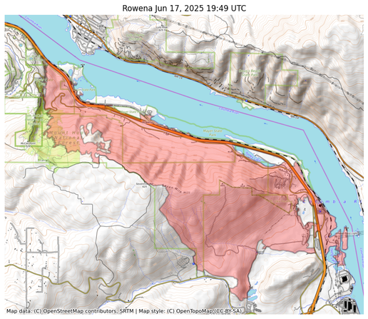
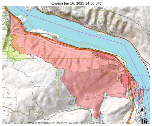
#RowenaFire ACRES 3,700 CONTAINMENT 99%
#AlderSpringsFire ACRES 3,279 CONTAIN. 82%