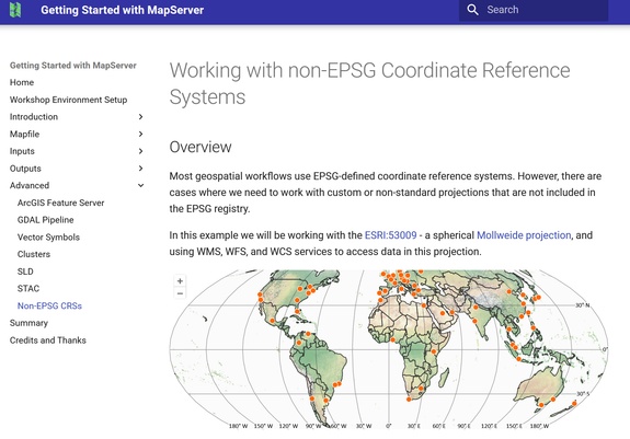
#MapServer für Fortgeschrittene im Mai 2026! 🚀

📑 „MapServer für Fortgeschrittene":
- Run-time Substitution & dynamische Karten
- Geomtransform & fortgeschrittene Symbolisierung
- Clustering, Kaskadierung & Color Ranges
- PHP-Fassaden & reguläre Ausdrücke

📍 Online
📆 12.–13. Mai 2026 (2 Vormittage)
🕙 jeweils 09:00–12:00 Uhr

👇
https://foss-academy.com/mapserver-fuer-fortgeschrittene/

#WebGIS #OGC #Kartographie #OpenSource #FOSSGIS @wheregroup

Erweitern Sie Ihre #MapServer Skills im Mai 2026! 🚀

📑 „Einführung in MapServer":
- Installation & Mapdatei-Konfiguration
- WMS & WFS – OGC-Standards in der Praxis
- Raster- & Vektordaten einbinden
- Klassifizierung, Symbolik & Diagramme

📍 Online
📆 05. – 08. Mai 2026 (4 Vormittage)
🕙 jeweils 09:00 – 12:00 Uhr

👇
https://foss-academy.com/einfuehrung-mapserver/

#WebGIS #GDI #OGC #OpenSource #FOSSGIS @wheregroup

A new, nice little tool: #Mapfile previewer. Browser-based app that allows you to edit #MapServer #mapfiles preview them in #WMS or #WFS

https://github.com/Consortis-Geospatial/Mapfile-Preview

GitHub - Consortis-Geospatial/Mapfile-Preview: MapFile Preview is a browser-based tool that helps you edit MapServer mapfiles and immediately preview what they publish (WMS/WFS). It includes a UI for editing text and viewing the map, and an API service that reads/writes mapfiles from a workspace folder, validates them with MapServer.

MapFile Preview is a browser-based tool that helps you edit MapServer mapfiles and immediately preview what they publish (WMS/WFS). It includes a UI for editing text and viewing the map, and an API...

GitHub

25 Jahre #MapServer – performant, flexibel, liebenswert 👀

🌐 Warum ist der MapServer nach einem Vierteljahrhundert noch immer so beliebt? Spoiler: Es liegt an seiner Architektur!

Jörg Thomsen erklärt auf der #FOSSGIS2026:
• Mapfiles – ideal für Git & Infrastructure-as-Code
• Runtime Substitution & dynamische Parameter
• Minimaler Ressourcenverbrauch bei hoher Performance

📅 Fr, 27. März | 12:20 Uhr
📍 Raum HS1 (ZHG 011)

👉 https://pretalx.com/fossgis2026/talk/ZBZ8GN/

#WebGIS #DevOps #OpenSource

Warum ich nach 25 Jahren den MapServer immer noch lieb habe FOSSGIS-Konferenz 2026

MapServer gehört zu den ältesten Open-Source-WebGIS-Projekten und überzeugt auch heute noch durch einzigartige Stärken: textbasierte Konfiguration perfekt für Git, Runtime Substitution für maximale Flexibilität, geringer Ressourcenverbrauch bei hoher Performance.

Zeitreise auf der Karte: WMS-Time in der Praxis 🕔️

🌐 Geodaten verändern sich über die Zeit – doch ein Standard-WMS zeigt nur eine Momentaufnahme.

Thekla Wirkus zeigt auf der #FOSSGIS2026: TIME-Parameter in #MapServer & #QGIS, Zeitreihen im #Mapbender & zeitbasierte Dienste am Desktop 📑

👀 Ideal für dynamische Daten wie Wetter, Pegelstände oder historische Entwicklungen.

📅 Fr, 27. März | 14:55 Uhr
📍 Raum HS1 (ZHG 011)

👉 https://pretalx.com/fossgis2026/talk/3FKFHQ/

#WMSTime #OGC #Geodaten

WMS-Time: Nutzung von Diensten mit zeitlicher Komponente FOSSGIS-Konferenz 2026

WMS-Time unterstützt Anfragen mit Zeitangabe; dies erfolgt durch Bereitstellung eines TIME-Parameters mit einem Zeitwert. MapServer und QGIS unterstützen die Verwendung dieses TIME-Parameters.

No more need to set ows_onlineresource in each of your Mapfiles - set MS_ONLINERESOURCE once in your CONFIG file ⚙️ https://github.com/MapServer/MapServer/pull/7434 #mapserver
MS RFC 141: Add MS_ONLINERESOURCE to CONFIG file by geographika · Pull Request #7434 · MapServer/MapServer

Implementation of RFC 141. Adds a new MS_ONLINERESOURCE to the MapServer CONFIG file. CONFIG ENV MS_ONLINERESOURCE "https://maps.example.com/" END MAPS EXAMPLE ...

GitHub
🚀 #OGC Features API Part 3 Filtering implementation for #MapServer https://github.com/MapServer/MapServer/pull/7433
OGCAPI Features Part 3 Filtering: add support for 'Queryables' and 'Queryables as query parameter' by rouault · Pull Request #7433 · MapServer/MapServer

Support 2 conformance classes of OGCAPI Features Part 3 Filtering (more to come) http://www.opengis.net/spec/ogcapi-features-3/1.0/conf/queryables-query-parameters Add a new layer metadata item &...

GitHub
Thanks to everyone who’s responded to the survey so far — including the two Steve Limes! 😄
Please boost outside the Fediverse too if you’re on Bluesky or LinkedIn - https://docs.google.com/forms/d/e/1FAIpQLSfNLqslbM6IhocnwTst9c29eaD89yD81hdUKW2ctn2uZK0Z3g/viewform #mapserver #osgeo
📣 MapServer users!
The first-ever #MapServer User Survey is live 🎉
Your feedback will help shape the project’s future roadmap.
Survey open until end of March 2026.
👉 https://docs.google.com/forms/d/e/1FAIpQLSfNLqslbM6IhocnwTst9c29eaD89yD81hdUKW2ctn2uZK0Z3g/viewform
2026 MapServer User Survey

The MapServer Project Steering Committee (PSC) would love to get your feedback on MapServer. Your input will help us understand how the project is being used and guide the development of its future roadmap. The survey will be open until the end of March 2026. Providing your name and email is entirely optional. All responses, including names and emails (if provided), will remain confidential. No identifying information will be published, and results will be aggregated and anonymised. Thank you for your valuable time and feedback. To make the survey more effective, please help us by sharing it widely.

Google Docs