Less than 4 miles away from the planned #Datacenter in #SanfordME in nearby #Kennebunk

#KennebunkPlains #Wildlife Management Area

"#KennebunkLandTrust was a partner in the protection of this landscape scale 2,000-acre property. Now managed by #TheNatureConservancy, this preserve offers outstanding opportunities for recreation and observation. Former blueberry barrens, the land is managed for many unique and #RareSpecies of #birds, #reptiles and #plants. Maine’s largest flock of #endangered #GrasshopperSparrows lives here, as does the rare #BlackRacerSnake. The world’s largest population of #NorthernBlazingStar, a threatened flowering plant, blooms here in August and September."

Learn more:
https://kennebunklandtrust.org/preserves/kennebunk-wildlife-management-area/

#MainePol #MEPol #Datacenters
#EndangeredSpecies #ConservationLand #NoisePollution #ProtectTheForests

A couple of miles away from the planned #Datacenter in #SanfordME ...

#LowerMousam #Wetland #Easement

"In December of 2020, the City of Sanford connected a 390 acre solar project to the grid. This 50 MegaWatt system offsets an estimated ½ million tons of carbon dioxide emissions per year, was the largest solar project in Maine, and the largest solar project at an airport in the world. To satisfy the negatively affected natural communities and habitats, mitigation was required. This mitigation resulted in the purchasing of various parcels of land somewhat equivalent to those disturbed, transferred to the City, and a Conservation Easement attached. This Easement, The Lower Mousam Wetland Easement, was deeded to the Trust for perpetual oversight along with another 107.62 acre parcel, located between the Harry Howes Road and Route 11A in #SpringvaleME called #TheMurrayEasement.

"The use on the property has many restrictions, but limited recreational activities are allowed within the scope of the Easement. Access is via CMP power line corridor at Jagger Mill Road, and canoe via #MousamRiver at Emery Street. Footpath designing and building is not currently being planned in this relatively remote area."

FMI:
https://mousamwaylandtrust.org/2023/01/19/lower-mousam-wetland-easement/

#MainePol #MEPol #Datacenters #ConservationLand #MousamRiver #NoisePollution #ProtectTheWetlands

Lower Mousam Wetland Easement

In December of 2020, the City of Sanford connected a 390 acre solar project to the grid. This 50 MegaWatt system offsets an estimated ½ million tons of carbon dioxide emissions per year, was the la…

Mousam Way Land Trust

Within the #MassabesicExperimentalForest , the #CharlesESwettTrail is considered a #Birding hotspot!

"Gorgeous in every season, the Charles E. Swett Trail is well worth taking a few moments to walk. The trail is short, but bring a book or a lunch, and take your time watching the waters of Estes Lake. For a longer journey, considering linking this trail with the other trails in the Massabesic Experimental Forest (Ida Jim Road to Clayton Carl Trail, Atlantic White Cedar Loop, B.C. Jordan Trail, and Littlefield Trail)."

List of birds (76 species in all):
https://ebird.org/hotspot/L3812097/bird-list

Source of description:
https://birdinghotspots.org/hotspot/L3822627

#NoDatacenters #MainePol #MEPol
#Datacenters #ConservationLand
#MousamRiver #EstesLake
#NoisePollution #ProtectTheForests #BirdingHotspots

Bird List - Massabesic Experimental Forest--Ida Jim Rd., Alfred, York, Maine, United States - eBird Hotspot

Explore a complete list of bird species observations in this region.

#MaineByFoot - #MassabesicExperimentalForest
#AlfredME

Preserve Size: 3,700 acres

"This experimental forest, which is used by the U.S. Forest Service for forest ecology and management research, is better organized for walking than its northern partner, the Massabesic Experimental Forest in Lyman.

"Here there are a few well-blazed, easy-to-follow footpaths, as well as a 1-mile old forest road cutting through the land that is flat and easy. Additionally, there are several twisty trails that aren’t blazed but seem as if they would appeal to mountain bikers. These unmarked tracks are often identifiable by small boulders parked at their entrance where they split from the old forest road. I’ve marked the blazed and un-blazed trails with different colors in my map.

"An interesting spot in this area is the largest #AtlanticWhiteCedar #wetlands in #NewEngland, which you can visit by hiking the 1-mile #ClaytonCarlTrail to the #AtlanticWhiteCedarTrail. These paths are accessed from the main track, on the west side of the forest.

"Additionally, there is a very pretty short trail on the other side of #WhichersMillRoad. The easy and wide 0.5-mile #CharlesESwettTrail takes you to the shores of #EstesLake. The rocks here look like they would make good swimming perches."

Learn more:
https://mainebyfoot.com/massabesic-experimental-forest-alfred/

#NoDatacenters #MainePol #MEPol
#Datacenters #ConservationLand
#MousamRiver #EstesLake
#NoisePollution #ProtectTheForests

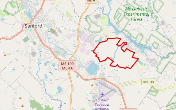
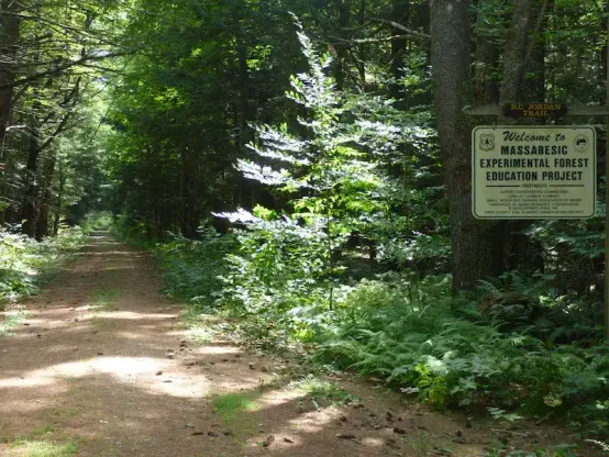
[Thread] So these are some of the places near the planned #Datacenter in #SanfordME. Sure, there may not be a lot of *humans* living nearby, but there sure is a lot of #wildlife who call these places home...

Company Eyes Sanford Site for Data Center

February 20th 2026

"A Texas company is exploring the feasibility of developing a massive data center in south Sanford.

New England Energy owns 1,060 acres of woods and has been quietly inquiring about the suitability of the site for a 100 to 300 megawatt capacity data center. Existence of the potential project burst into the open during a Maine legislative committee last week, and more details are surfacing."

Read more:
https://sanfordspringvalenews.com/company-eyes-sanford-site-for-data-center/

Archived version:
https://archive.ph/UExIR

#MainePol #MEPol #Datacenters #MassabesicExperimentalForest #ConservationLand #MousamRiver #EstesLake #NoisePollution #ProtectTheForests

Green Party bill to ban mining on public conservation land drawn in Parliament

The member's bill would prohibit new mining, prospecting and exploration permits across New Zealand's 8.5 million hectares of public conservation land.

RNZ
Gold mine on conservation land in Golden Bay denied permit

An Australian mining company planned to extract billions of dollars of gold at Sams Creek, but NZ Petroleum and Minerals has declined the application.

RNZ

More about #BaunegBeg ! The name comes from the #Wabanaki word #Bannebeaugue, which means “spread out” and “still water.”

"Bauneg Beg Conservation Area in North Berwick includes 89 acres of deciduous forest land surrounding the 866-foot, three-peaked Bauneg Beg Mountain. The land was acquired by Great Works Regional Land Trust in three parts over the course of seven months in 2000 and 2001.

The 0.65-mile trail winds through a deciduous forest, a pine grove and a section of large boulders described as "Devil's Den" before reaching the highest of the three peaks. Trail forks just before the summit with a choice of routes to the top. Easier trail veers to the right.

Rocky outcroppings offer views of nearby Mount Hope, parts of south Sanford and, according to Great Works Regional Land Trust, on a clear day, Mount Washington to the northwest and the Atlantic Ocean to the southeast."

https://www.alltrails.com/trail/us/maine/bauneg-beg-middle-mountain-trail

#SolarPunkSunday #ConservationLand #MaineTrails #MaineHikes #SpendTimeInNature #NorthBerwickME #ConservationLands #GreatWorksRegionalLandTrust