#SevereWeather #CarolineCounty #Ladysmith
BakersRelay corner of Caroline County comes under the gun through 2:30 pm EDT. If I lose power please continue to follow
@easwatch
#VAwx
#NCwx
#MDwx
#DCwx
#SevereWeather #CarolineCounty #Ladysmith
BakersRelay corner of Caroline County comes under the gun through 2:30 pm EDT. If I lose power please continue to follow
@easwatch
#VAwx
#NCwx
#MDwx
#DCwx
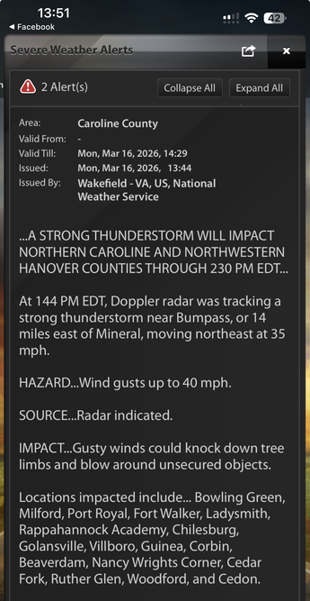
#VAwx #CarolineCounty #Ladysmith
Special Weather Statement
National Weather Service Wakefield VA
245 PM EDT Sat Apr 26 2025
...STRONG THUNDERSTORMS WILL IMPACT NORTHERN LOUISA...NORTHWESTERN
KING AND QUEEN...CAROLINE AND NORTHWESTERN HANOVER COUNTIES THROUGH
330 PM EDT...
At 245 PM EDT, Doppler radar was tracking strong thunderstorms along
a line extending from near Ladysmith to near Bumpass to near Louisa.
Movement was east at 25 mph.
HAZARD...Wind gusts up to 50 mph and half inch hail.
SOURCE...Radar indicated.
IMPACT...Gusty winds could knock down small trees and blow around
unsecured objects. Wind impacting handling of high profile
vehicles. Minor hail damage to vegetation is possible.
Strong thunderstorms will be near...
Ladysmith, Louisa, Bowling Green, Milford, and Mineral around 250
PM EDT.
Bumpass around 255 PM EDT.
Other locations impacted by these storms include Chilesburg, Beazley,
Golansville, Louisa Airport, Guinea, Elevon, Penola, Nancy Wrights
Corner, Trevilians, and Cedar Fork.
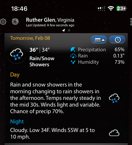
Good evening Ruther Glen! Tomorrow morning look for rain and snow showers changing to all rain in the afternoon. Winds light and variable. Chance of precipitation is 70%.
Data by WeatherMate
#VAwx #CarolineCounty #RutherGlen
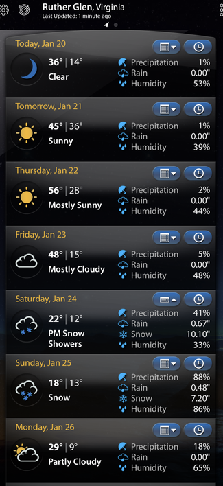
It’s going to be a brutal week folks. Data by WeatherMate.
Good evening folks! NWS warning has updated snow potential for Caroline County and added a warning for heavy sleet accumulation. Stay off the roads overnight and tomorrow if you can. The Federal Government, Fredericksburg City schools and Spotsylvania County Schools have already put out closure notices for Monday.
Data from WeatherMate
Winter Storm Warning for Caroline County is up. Please finish your storm preparations and if you can STAY OFF THE ROADS!
Aside from watching what Winter Storm Blair is going to crank out for us overnight Sunday into Monday in Caroline County and further north, PLEASE be cognizant of our freezing temperatures this week. The nights are going to be brutal so remember to prepare and check on PEOPLE, PETS, PIPES AND CARS. Be safe folks!
Data from WeatherMate