Alert: Section of East Lake Sammamish Trail will be closed May through the end of 2026 with no detour

From King County Parks.

This one is a bit rough.

The East Lake Sammamish Trail and adjacent roadways will all be closed starting “as early as May 2026 and lasting through the rest of the year,” according to King County Parks. There will be no official detour.

For most of the year, the only ways to bike between Issaquah and Redmond will be to go around the west side of the lake or to climb the streets through Sammamish. Neither option has the protection and accessibility of the trail.

— Advertisement —

The trail, Shore Lane and E Lake Sammamish Parkway NE will all be closed at the same time so the City of Sammamish can restore the George David Creek waterway, which currently inhibits salmon passage. When the work is completed, the stream will be open to the air rather than trapped in underground pipes, and the trail will have a cool new creek overlook. So it’s a good project, but a rough closure this year. The trail will be closed between Louis Thompson Road NE and NE Inglewood Hill Road.

It’s frustrating that once again King County refuses to even sign a detour option for folks, instead leaving people to figure it out themselves. It signals that they do not take bicycle transportation seriously and instead consider bicycle trips expendable or for recreation only. Not everyone reads Seattle Bike Blog and will be aware of this closure and how to get around it. Based on what I can determine looking at the map, there should be a way to get around the closure via Louis Thompson Road NE and NE Inglewood Hill Road, though I have not tried the route myself to confirm. It does not look like these roads are too busy, though that could change if they become part of the roadway detour. The shortest detour I can find includes two very steep sections with about 360 feet of elevation gain as well as some sections of roadway without bicycle infrastructure. Still, at least from a cursory glance this seems preferable to going around the west side of the lake, though I would love to hear other opinions. If you are familiar with the area, please let us know in the comments below what routes you would suggest.

#SEAbikes #Seattle

Alert 4/6 and 4/13: Elliott Bay Trail closed overnight in Myrtle Edwards and Centennial Parks

Much like the late March closure, the Elliott Bay Trail in Myrtle Edwards and Centennial Parks will be closed overnight “as early as” April 6 and then again April 13, according to the Elliott Bay Connections team. Both the walking and biking paths will be completely closed from the Sculpture Park to Expedia campus from 8 p.m. to 5 a.m. the next morning. The work is weather dependent.

See our previous post for ideas on how to get around the closure. There are no great options, so you may want to consider taking a longer detour via Westlake and the Ship Canal Trail if that works for your route.

#SEAbikes #Seattle

Alert 3/30-31: Elliott Bay Trail will be fully closed overnight in Myrtle Edwards Park

All overnight trail access will be closed through Myrtle Edwards and Centennial Parks March 30 and 31, according to a notice from the Elliott Bay Connections team that SDOT posted to Bluesky.

Both the walking and biking paths will be closed from the Olympic Sculpture Park to the Expedia campus starting each evening at 8 p.m. and reopening each morning at 5 a.m.

Especially for folks heading home late on those evenings, note that there is no good alternative route near the trail. You’ll pretty much be limited to biking on Western and Elliott Avenues, which is not very comfortable. There is sidewalk on Elliott Ave that might not be too full of people later in the evening or overnight. Then you can take the Helix Bridge and find your way behind the Expedia campus back to the trail (UPDATE: As pointed out in the comments below, a stretch of Alaskan Way W is actually owned by Expedia and not the public even though it looks and feels like a public street. This was a surprise to me. Hopefully Expedia can be cool about it for these two nights). Alternatively, consider starting your detour further south and going the other way around Queen Anne via Westlake and the Ship Canal Trail. Depending on your destination it may be a bit longer, but much nicer and less stressful.

The closure is part of the Elliott Bay Connections project, which has fully remade the waterfront park area and created a new path along the east side of Alaskan Way. That project is anticipated to be complete by the summer.

#SEAbikes #Seattle

Alert 2/25-Mid March: Curved section of Waterfront Bikeway will close to fix standing water issue

Map from the SDOT construction notice (PDF).

The short walled-in section of the waterfront bikeway between the Overlook Walk and Alaskan Way will be closed starting as early as today (February 25) for two weeks as crews work to fix some water drainage issues. People biking can either ride on the street, use the north sidewalk, or use the park promenade to get around the closure.

As always, people biking must yield to people walking. The Waterfront may even instruct people to walk their bikes on the promenade.

The work involves tearing up some of the asphalt and installing new drainage infrastructure, and the bikeway will be closed 24/7.

#SEAbikes #Seattle

Alert 2/16-April: King County will detour vehicle access onto Snoqualmie Valley Trail near Rattlesnake Lake, close the trail to biking and walking

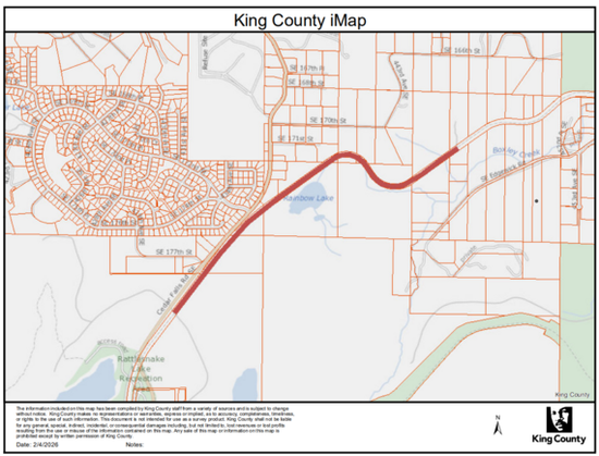
Map of the closure from King County Parks.

As part of ongoing work to make road and other infrastructure repairs following this winter’s intense flooding and rainfall, the Snoqualmie Valley Trail will be closed to walking and biking “as soon as February 16” as crews work to repair the nearby SE Edgewick Road, according to an alert from King County.

This is a very unusual closure because the trail is closed not to repair it but because it is the only viable alternative vehicle detour around the closed roadway for a handful of properties west of the worksite that would be otherwise cut-off from the road network while roadway repairs are underway. “This portion of the trail will be temporarily closed to pedestrian and bicycle users to facilitate safer conditions for vehicle traffic,” according to the project webpage.

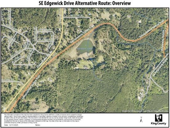
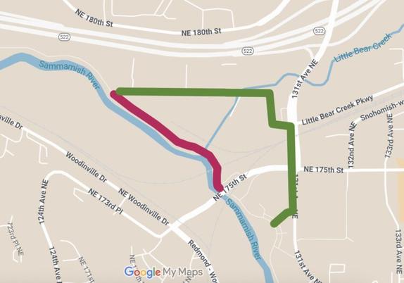
The temporary vehicle access route.

It is understandable that these properties need basic roadway access during the 6–8 week closure, and there truly does not seem to be any other option. These are extenuating circumstances. But there is also no viable detour for trail users in this area, and trail users are also members of the public worth serving. This closure creates a similar problem as a bridge replacement project in early autumn 2024. The only real alternative option for folks biking between North Bend and Rattlesnake Lake is to bike on Cedar Falls Road SE, which can be busy (especially on a nice day) and has limited to non-existent shoulders. Discretion is advised.

Given the options, I’d much rather bike on the trail with a limited number of cars using it for temporary property access than ride on Cedar Falls Road. The temporary road access route will not be a through-route, so it shouldn’t have significant traffic flow. People bike mixed with cars on skinny streets all the time, and bikes are legal vehicles that are generally allowed on roadways except for a handful of limited access freeways. The detour instructions on the project website tell people driving on the trail to “keep speed under 10 mph.” If there were some other nearby sidewalk they could use to route trail users, then maybe I could see banning biking and walking on the trail. But King County has no safe detour to offer and does not plan to sign one.

King County Parks has gotten into a bad habit of treating trail trips as optional, but that isn’t always true. Sure, those who are just looking for a nice ride and don’t really care where they go should consider a different route. But there are jobs and homes out there, and people rely on King County trails for transportation. One third of U.S. residents cannot drive, and there is limited transit service in the area (no transit service on weekends). There will also certainly be folks who do not read Seattle Bike Blog and will be surprised by this closure in the middle of a rather remote area. They deserve to be offered a viable option. King County Parks needs to revise its policies so that “there will be no detour” is not longer treated as a catch-all phrase to absolve them of their responsibility to people who use and rely on these trails.

More details from King County Parks:

As soon as February 16, a segment of the Snoqualmie Valley Trail will be closed to people biking and walking to allow for temporary vehicle access while SE Edgewick Road undergoes repairs. The anticipated duration of this closure is approximately 6–8 weeks.

There will be no detour available during this closure. 

When King County Parks closes a trail, safety is our top priority. We carefully evaluate whether a detour is feasible for each closure. Because regional trails are accessible, multi-use facilities, any detour must safely accommodate pedestrians and cyclists of all ages and abilities and meet ADA requirements.

In this location, it is not possible to provide a detour that meets these safety and accessibility standards. We recognize that trail closures are disruptive. King County Parks remains committed to providing advance notice whenever possible, carefully planning the scope and timing of work to minimize impacts, and completing projects as quickly and efficiently as conditions allow. 

Thank you for your patience and understanding as we complete this important work. 

#SEAbikes #Seattle

Alert 2/14: Crew will be filming on Burke-Gilman Trail in Fremont

Map from the Seattle Film Office.

If you were planning to bike with your sweetie to make out by the Sri Chinmoy statue in Fremont on Valentine’s Day, I’m afraid I have bad news for you. A crew will be filming along the Burke-Gilman Trail between the Fremont and Aurora Bridges Saturday. Trail users should expect intermittent holds starting at points near each bridge between 2 and 6 p.m. So you’ll have to wait or just bike on Northlake Way, which is more like a parking lot access road than a street in this area.

The Seattle Film Office reached out to Seattle Bike Blog to spread the word. It’s great to see the office being proactive, perhaps the result of some procedure changes following the Bicycle Weekends fiasco in September. More details:

We are writing to share awareness of a film production which will have temporary impacts to a short section of the Burke Gilman Trail. To ensure safety for the public and for the film production crew, our office is coordinating with Seattle Parks & Recreation, Seattle Department of Transportation, and Seattle Police Department for the filming. We would like your help us get the word out in advance to bicyclists who may be impacted by the filming activity. Additionally, do you have any suggestions of other biking community media or neighborhood organizations we should contact to share this announcement?

When: 2:00PM to 6:00PM, Saturday, February 14, 2026

What: Filming with intermittent 2-3 minute bicycle and pedestrian delays along the trail during film “takes”

Where: Cheshiahud Lake Union Loop/Burke Gilman Trail between Fremont Bridge and N Northlake Way

Details: Film production assistants in orange vests will be performing 2-3 minute holds of bicyclists and pedestrians during takes while the production films an actor riding a bicycle along the Burke Gilman Trail at the turn between the Fremont Bridge and N Northlake Way. Please see attached map for specific location details.

Why Here? The production has chosen Seattle as its filming location because of its varied location “looks,” and has chosen this section of the Burke Gilman Trail because of its spectacular view of the Ship Canal and Aurora Bridge in the background.

#SEAbikes #Seattle

Flood breaches Green River levee in Tukwila, evacuation area includes both Green River and Interurban South Trails

Screenshot from King County Sheriff helicopter footage.

The Desimone Levee has failed between S 180th and 190s Streets, triggering an emergency “GO NOW” evacuation order from King County. UPDATE 10pm: The area under the GO NOW order has been significantly reduced since the initial alert, and a stretch from the Green River to SR-167 that includes both the Interurban South and Green River Trails is under a flood alert. King County has an emergency alert map that shows exact areas under active alerts.

As KIRO 7 reported, emergency crews have so far contained flood waters to a relatively small area within a block or two of the breach, but more rain is in the forecast.

The Green River Trail sits on top of the breached levee, and footage of the breach shows a section of the trail completely missing. So needless to say, the Green River Trail is closed and will likely remain closed even after this flood event.

Do not attempt to bike through flood water even if the level is low. Not only can flows be stronger than they appear, but flood water contains sewage and other nasty industrial stuff that you don’t want to deal with.

There is no easy detour if both trails are closed. Military Road is probably the best alternative bike route between Kent and South Park that avoids the evacuation zone (from South Park: Des Moines Memorial – Military Road – S 152nd Street – 42nd Ave S – Military Road). It has painted bike lanes or decent shoulders much of the way around the flood area, but it is not a comparable experience to biking on a trail. Another option is to take your bike on the light rail, which now has stations at Kent Des Moines, Star Lake and Federal Way.

This map below from King County shows the initial emergency area, which is also a map of areas that could be at risk if flooding significantly worsens and the levee fails completely. So if you are in this area but not in the smaller GO NOW area, be on alert.

Evacuation map from King County.

#SEAbikes #Seattle

Two Foothills Trail bridges closed pending additional inspection for flood damage – UPDATED

Photo from Pierce County Parks.

UPDATE 12/18: The bridges are OK! Read our update.

Original story:

As expected, we have more concerning trail news to share as flood waters finally start to recede at least for now. Pierce County Parks has officially closed two bridges on the Foothills Trail near South Prairie and Orting, one over South Prairie Creek and one over Voight Creek.

This area experienced major flooding in recent days, and Parks crews are concerned about whether debris flows damaged these two trail bridge structures. So until they can inspect them more closely, the bridges are closed indefinitely. Much of the trail in the area is also a huge mess and in an active emergency area, so officials are asking people to stay away as of December 12.

Once the general closure is lifted, Pioneer Way will likely the best trail detour option around the closed bridges even though it does not have sidewalks or bike lanes. Hopefully inspectors do not find significant damage and are able to reopen the full trail. After decades of advocacy and work, the community celebrated in September the first time all of the bridges on the Foothills Trail were open from Puyallup to Enumclaw.

More details from Pierce County Parks:

Following recent inspections along the Foothills Trail, the South Prairie Creek pedestrian bridge (approx. 1000 ft. East of South Prairie Trailhead) and the Voight Creek pedestrian bridge (approx. 1 mile East of Orting City Park in downtown Orting) will remain closed until further notice. Significant debris has accumulated at both locations, creating unsafe conditions for crossing.

Parks staff are currently on-site monitoring the situation. The Pierce County Planning and Public Works Transportation Bridge Engineering team will conduct additional inspections on Monday to evaluate any damage and determine when the bridges can safely reopen. Thank you for your understanding. 

#SEAbikes #Seattle

Palouse to Cascades Trail significantly damaged by washout and landslide due to heavy rain – UPDATE: Trail is closed west of Easton

Photo from WSDOT.

The extreme rainfall this week has triggered washouts and landslides that have damaged the Palouse to Cascades Trail. WSDOT posted a photo of a significant slide that has destroyed at least a dozen feet or so of the trail and damaged the hillside below it. Because it is relatively near I-90, WSDOT is monitoring the slide.

UPDATE 12/11: Washington State Parks has closed essentially all access to the trail between Rattlesnake Lake and Easton. More details below.

According to a post on the Washington Hikers and Climbers Facebook group, the slide is west of the Mount Washington Trailhead, which would put it about halfway between the Ragnar and Garcia railroad signs. More heavy rainfall is on the way, so hopefully the damage does not get even worse.

Meanwhile, a post on the NWHikers forum by user Randito shows a significant washout on the trail, which they wrote is on the east side of the pass between Hyak and Keechelus Dam. It looks like the birth of a new mountain stream, right across the trail. Washington State Parks posted a notice that the trail is closed from Hyak to Easton: “Near Hyak and Cabin Creek on the Palouse to Cascades Trail, there has been wash outs cutting through the trail. The trail will be closed from Hyak to Easton until we can repair the trail and safely reopen.”

I will update this post if I learn more about these closures.

UPDATE: Washington State Parks told Seattle Bike Blog Thursday that all trailheads from Cedar Falls (near Rattlesnake Lake) to the Snoqualmie Tunnel are closed as well as the stretch of trail from Hyak to Easton. In other words, don’t try to use the trail anywhere west of Easton. From WA Parks:

Currently all trailheads from Cedar Falls to the Snoqualmie Tunnel are closed; we’ve had two separate slides, one of which is still active.

With a forecast of continued rain, travel along this section of trail is not safe.

For the Central part of PTCT, the closure extends from Hyak trailhead (Hyak Sno-Park) to Easton, due to washouts near Hyak and Cabin Creek.

The I-90 Exit 54 interchange on SR-906 also had road damage due to weather related issues. The road to Hyak Sno-Park and the Sno-Park itself are closed.

We will provide updates on an estimated timeframe for repairs and reopening after the storm subsides and we can safely assess the damage.

The storied trail was initially built as a railroad 110 years ago and is now a highlight of the Great American Rail-Trail.

With more rain on the way and lots of other more pressing flood damage across the region, it is too early to fully assess the damage to the trail. However, at first glance it doesn’t look like an inexpensive or easy fix. Slide areas can become recurring problems once they begin and can be difficult to shore up.

There is likely more damage on this and other trails in the area, so please use caution. Do not mess with fresh slide areas, as they can be delicate and can widen with little warning. Don’t try to hike or bike around one. If a slide blocks your way, you just need to turn around and go back. Likewise with flooded trails.

#SEAbikes #Seattle

Alert 11/3-14: Sammamish River Trail ‘intermittent’ closures near NE 175th St + 2 days of full closures, dates TBD

The red marks the approximate work area. The green marks a possible unofficial detour route. Map by Seattle Bike Blog.

King County Parks is fixing a section of pavement on the Sammamish River Trail between NE 178th and NE 175th Streets in Woodinville, so expect “intermittent” closures between November 3 and 14. There will also be two full-day closures at some point during this work period, though those dates have not yet been announced.

Once again, the county is not creating a detour, saying, “No detour is guaranteed during these closures. Please plan for alternate routes.” This is a pattern with King County Parks for trail work, and one more example of why the county needs to create a proper trail detour policy that treats the trail as a transportation corridor rather than just a park for recreation. This is a very busy trail, one of the gems of the region’s trail network. The County must secure a reliable and safe detour option for people.

Bob Svercl and I have both been looking at the options, and there should be an OK detour option via NE 178th St, 130th Ave NE/Little Bear Creek Pkwy, 131st Ave NE, and Wilmot Gateway Park, but this route requires a fence gate at NE 178th St to be open. I believe it usually is open, but technically a few feet of land between the trail and the street might be private property (it is sometimes difficult to know how accurate the Parcel Viewer website is at such a detailed scale and where street right of way begins and ends). I believe the gate is often unlocked, and the Strava heatmap (account needed to zoom in) suggests that trail users pass through the gate fairly often. But if that gate is closed, then I don’t know what people are supposed to do. The two freeways and the river pen the trail into a corridor with no other access points for at least a 1.3 miles to the west, so it will be very important that the gate stays open at all times that the trail is closed.

We need King County to ensure people can access NE 178th and that folks know they need to go all the way to Wilmot Gateway Park or the the south sidewalk on 175th to reconnect to the trail. The connection will not be obvious to users on the ground, which is why signing a detour is important. Not everyone reads Seattle Bike Blog, unfortunately.

Details from King County Parks:

Starting Nov 3-Nov 14, A portion of the Sammamish River Trail between NE 175th St and NE 178th St will experience intermittent closures over a two-week period to remove and repair asphalt on the trail. 

Trail users should expect up to two full 24-hour closures during this work period. Additional shorter closures may occur for striping activities. Single-lane closures may also be required for sign installation. 

No detour is guaranteed during these closures. Please plan for alternate routes. 

Thank you for your patience as we complete these necessary improvements.

Questions? Contact [email protected] or (206) 477-4527. 

#SEAbikes #Seattle